This expedition was organised through Jagged Globe Mountaineering
Sunday 7 November / Monday 8 November
Gillian dropped me at Birmingham Airport and I checked in with a bag more than 10kg overweight, costing me £120 excess! Met Tim, another member of the team, and travelled to Amsterdam to connect on to a KLM flight to Quito. Here we met some of the others. Matt, a finance manager for Brittanic Insurance and Steve, an RAF Intelligence Officer who spends his time flying around in Nimrods. Also Robert, a retired solicitor from Kendal (and previously a District Officer in Tanganika), who seems well connected in Lakeland climbing circles.
The flight to Quito took off on schedule but realisation had dawned that we would not arrive in Quito for another 17 hours, once I had worked out the difference based on time zones. It transpired that we were to stop at Bonaire in the Dutch Antilles (off the coast of Venezuala) and wait a couple of hours before flying down to Ecuador´s largest city, Guayaquil, for refuelling.
 |
| Refuelling in Bonaire |
It was surreal getting off the plane in the middle of the night in Bonaire, where the temperature was 28 degrees with a refreshing sea breeze. In the transit lounge we met Smiler Cuthbertson, our Jagged Globe guide, and other members of the team including Peter, a rather quiet paramedic from Grassington in the Yorkshire Dales. Smiler is Wolverhampton born, but then spent 25 years in N Wales as an avid rock climber, before moving to Scotland. He now lives near Loch Ness and ´commutes´ 40 minutes to the Cairngorms. The flight from Bonaire to Guayaquil took about 3 hours, taking off as the sun rose in the east behind us. We flew over Curacao and then over the mountains and jungles of Venezuala and Columbia. There were a number of snow-capped volcanoes seen to the north of Columbia, a bit of a surprise. Much of the way was cloudy, but breaks in the cover as we flew into Ecuador afforded views of the Northern Highlands with densely forested areas on the western flanks of the Andes known as ´cloud forests´. Unremittingly mountainous for miles, we then descended over the western lowlands, famous for banana and tea cultivation, before landing at Guayaquil on a very dusty runway. One hour on the tarmac here and then a short hop to Quito with some views to the summits of Chimborazo and Cotopaxi peaking through an extensive bank of cumulus cloud cover. The descent over Quito was dramatic, with mountain ridges on either side of the aircraft before flying over the town close to the buildings, and landing just north of Quito.
We were swiftly through Immigration and Customs, and then bussed to the Hotel Reina Isabel in the New Town. It was warm, 28 degrees and the town was bustling with much traffic and associated exhaust fumes! Had a good room to myself. Met final members of the team; David Sayer, a retired executive previously with Norwich Union in London (61 I think, and a bit of a jungle lover) and Ro, the pleasant property company researcher who I had met during the pre-expedition weekend in N Wales a few months earlier. She had flown in from New York where she had been on business. We had a quick lunch nearby after a short briefing from Javier and his assistant Pepe, the local guides. Pepe was to be the key local guide for our trip as Javier was leading another Jagged Globe expedition to Antisana.
We then went off to visit La Mitad del Mundo (´the middle of the world´), near the village of San Antonia, 22km north of Quito. We visited the Mitad del Mundo complex where the guide took us through the centre, starting with a walk down the equatorial line...weird thinking that you had your left foot in the southern hemisphere and your right foot in the northern hemisphere!
 |
| On the Equator, La Mitad del Mundo |

The guide then took us through the huge variety of tribes and peoples resident in Ecuador. We moved on (increasingly exhausted by jet lag) to the nearby Museo Solar Ilti Nan with fascinating exhibits of the importance of Ecuador´s geographic location. Most notable was the ´water in the sink´ experiment where water drains vertically on the exact equator, but then when the sink is moved a couple of metres south, the water circles clockwise, and a couple of metres north, the water circles in the opposite direction as it drains away due to the Coriollis Principle. It has to be seen to be believed. The tour concluded with a quick visit to some traditional habitues of Ecuadorian jungle dwellers before hopping on the bus and returning to town. We had a quick dinner in the nearby Magic Bean restaurant before turning into bed at 2015.
Tuesday 9 November
Awoke at 0550 and wrote this log. Big views of the city from my room. Quito is at 2850m but, so far, the only feeling of altitude has been the usual thirst, so keep drinking the (bottled!) water! Met the Antisana team at breakfast, led by Richard, the likeable Jagged Globe guide. They were just setting off to climb Pasachoa for an acclimatisation walk, and all looked very fit and lean.
So, back to today. We set off on the bus for a tour of Quito at 0830, moving from the congested New Town, pass a number of parks, into the Old Town, where we left the bus at the Church of La Basilica, high on a hill to the north east of the area. We climbed right up to the highest point of the church (which is still under construction, having been started in 1926!), firstly by climbing a series of steep steel ladders taking us to a roof balcony, giving 360 degree views of Quito. Then down again, and via a different route up a spiral staircase then more steel ladders until we got into the belfry and above into one of the spires. Big views fo Quito, it is massive .. only a few kilometres wide but 46kms long! Bright but cloudy, so views of the many volcanoes were obscured.
 |
| La Basilica, Quito |
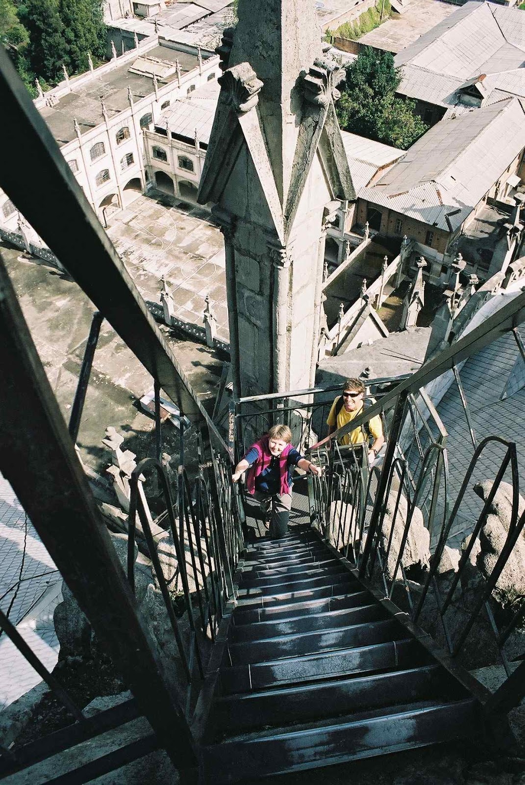 |
| Ascending La Basilica, our first climb on the expedition! |

 |
| El Panecillo from La Basilica |
 |
| Old Town Quito and El Panecillo |

We then commenced our walking tour of the Old Town, descending through the narrow streets bustling with many types of enterprise, small workshops, hardware stores, carpet and coffin shops, with indigenous locals selling fruit, avocado and broad beans on the streets. We had been told to watch for pickpockets and especially to hang on to our cameras.
Pepe eventually led us to the Plaza de la Independencia, having walked through the Archbishop´s Palace, now a colonnaded row of small shops and restaurants. Entering the main Plaza was a bit of a surprise. Very busy and seeing other tourists for the first time, but also with many locals sitting about, indigenous Indians begging or hawking everything from paintings to batteries, and a significant police and military presence! The latter, including police on horseback, police with tear gas masks and bullet proof vests, plus military with riot shields...all due to a possible demonstration against the President in this still politically unstable country.
 |
| Plaza de la Indepedencia, Quito |
 |
| Presidential Palace, Quito |
We then walked further east again in increasing sunshine, through a rather dodgy area and climbed the stairs of Calle Garcia Moreno, past a municipal washing/drying facility where women were seen doing their washing in a communal area. Half an hour later we reached the top of a hill called El Panecillo (´the little bread loaf´), topped by the statue of La Virgen de Quito, with a crown of stars, eagle´s wings and a chained dragon atop the world. Big views of the Old and New Town areas, albeit in hazy sunshine and with views of nearby volcanoes completely obscured.
 |
| Old Town, Quito |
 |
| La Virgen de Quito |
 |
| Expedition team, Quito |
Paid a quick visit to a local internet cafe and then the evening was spent at Javier´s apartment to the east of the town, involving a foggy cab ride to get there. Food (pizza) and a slideshow on the climbs, followed by a talk by Javier´s wife (a Dutch lady who was a stockbroker for ABN Amro in London, before doing voluntary work in a Nepalese hospital for kids affected by polio and suchlike). Her mission is now to help the street children of Quito and they are currently starting an orpahnage with capacity for five children.Once there, every effort will be made to trace the original parents (who often gave up their children due top economic circumstances) and help reintegrate the family, providing support to the parents as necessary. Failing that they will move to fostering/ adoption routes. Reminder: gift some $ before I leave Ecuador. David Baber, the final member of the expedition, also joined us at the apartment, just in from London via Madrid. Back to the hotel in a ´boy racer´ taxi (ran two red lights!) and after a final pack for the following day, turned into bed at 2200.
Wednesday 10 November
Awoke around 0500 and wrote this log. Foggy outside but Javier had mentioned last night that it may rain and fog in the valleys at this time of year, but the weather is relatively stable and you do get very clear summit conditions. Another point from yesterday ...remember to use sun cream! My face caught the sun yesterday despite wearing a peaked cap.
On the road at 0800 and after a 1 ½ hour drive south of Quito, we dropped luggage at the Hosteria Hacienda ´La Carriona´, near the viullage of Sangolqui. A traditional farmhouse with big courtyard, numerous cats and dogs, plus welcoming staff.
 |
| Hosteria Hacienda 'La Carriona' |
 |
| Fighting our way up Pasachoa! |
 |
| Pasachoa on the skyline |
 |
| Pasachoa, approaching the summit ridge |
My own performance was OK. Hard work on the steeper ground but the steady pace got us through. Dehydrated quickly as usual. Slow descent due to Ro and David S. who has bad knees! Eventually we all got down by 1700, with some tricky steep muddy sections to negotiate, then drinks and back to the hacienda by bus down very rough (and surprisingly busy) gravel tracks, passing through large stands of eucalyptus trees at the top end of the valley. Reached base at about 1830 and got a super twin room with wooden beams, wood floor, fireplace and comfy bed to myself. Shower, some washing, and laid out gear to dry followed by dinner at 1930. Beer in a cosy bar and steaks served on a griddle.
Conversation over dinner: David S. lives near Canberra 8 months of the year and in a flat in Norfolk for the balance of the time. His house in Australia is plagued by Tiger snakes and spiders are everywhere. Sounds ghastly. Apparently, Smiler started climbing when he was 15 after his then boss asked if he wanted to join him on a club trip to N Wales. He never looked back and is now a member of the Alpine Club and the more exclusive Alpine Climber's Club for the harder rock fraternity. He also makes a living doing industrial rope work which is apparently very lucrative... he once spent 7 weeks inside the cooling towers at Radcliffe Power Station near Nottingham!
Thursday 11 November
Breakfast followed by 0820 departure on the bus for Volcan Pinchincha, the closest volcano to Quito to the west of the city. Guagua Pinchincha 4794m has recently been active, with eruptions on a regular basis since 1999. Pinchincha has covered Quito in ash and closed the airport several times since then. Our bus journey took us high to the west of the city, affording further views of the huge sprawl that is Quito and taking us through some quite poor areas. Heading west, up more hills, we eventually crossed over a pass into beautiful green mountain scenery with tall pines and eucalyptus before turning off on to a very narrow and rough track, which climbed steeply up zigzags to 3700m. Smiler was very keen for us all to take the walk to Pinchincha very steadily to aid acclimatisation and we made steady progress up a gradually ascending track with occasional steeper sections, but essentially a series of long zigzags.
 |
| Looking up to the first summit of Pinchincha |
 |
| Pincincha Refuge 4555m |
Then, on a reasonable track, we made the final pull on to the first summit block, dumped sacs and scrambled along the ridge to the main summit. Straightforward scrambling, a bit like Striding Edge in the Lakes but at the same altitude as Mont Blanc, with run outs on either side to match! Then a short rock section to reach the summit, which we all did unroped. The summit was broad enough to relax and take photos, with stupendous views (as we were above the clouds) to the north and occasional glimpses of the precipitous crags down into the crater itself. Sulphorous fumes were emanating from the crater but were not particularly strong.
 |
| Scrambling to the summit of Pinchincha |
 |
| Summit ridge, Pinchincha |

 |
| Looking down into the smouldering crater of Volcan Pinchincha |
 |
| Crater rim |
 |
| Descending from Pinchincha |
The main summit group was Smiler, Matt, Peter, Steve, myself, Tim and David Baber (who, at 62, had walked really well, although he was last off the hill, 40 minutes behind the rest of us). Steve had been nauseous at the top and Smiler and I had both suffered from tingly fingers at the first summit, a sign of mild AMS, apparently quite common. It disappeared once I had started scrambling further along the ridge. We then had a two-hour bus ride back to the hacienda. It was fascinating to see the people of Ecuador at play having just returned from school and work...most of the suburbs were crammed with people on the streets, enjoying food from small cafes and street stalls, lads kicking footballs, internet cafes everywhere and a hive of activity everywhere you turned. As we dropped towards Quito we were delighted to see a somewht spectral view of the mountain Antisana to the east...a vision of what was before us! Bar, meal and bed by 2100.
Friday 12 November
Off at 0830 to reposition us at another hacienda, before lunch and a quick visit to the famous Otavalo market in the Northern highlands at 2550m. As we set off we immediately had clear views of Cotopaxi to the east and the clearest view yet of Pinchincha, with yesterday´s route visible. We drove to the east of Quito, traversing one side of the ´Avenue of the Volcanoes´ (as named by Humboldt) and avoiding the congestion in the city. Views to the south included the twin peaks of Illenizas Norte and Sud. A nice drive, with spectacular countryside and a clear view of Volcan Cayambe from a scenic viewpoint off the Panamericana highway, this being our next objective.
 |
| Cayambe from the Panamericana en route to Otavalo |
 |
| Otavalo market |

 |
| Barmaid, Otavalo |
 |
| Guinea Pig Island |
 |
| Hacienda Guachala , near Cayambe |
Late start from hacienda at 1030. After breakfast I had visited the chapel which contained a small museum, not much to write about except for a poster showing Whymper´s routes on most of the region´s big mountains in the late 19th century. It was cloudy for most of our journey with a quick stop in Cayambe for snacks then relentlessly eastwards toward the Cayambe Refuge. Road not bad, mainly cobbled, passing through verdant agricultural land with many smallholdings and white churches. Then disaster! A steep bend had a great hole in the cobbled surface into which our bus dropped. Attempting to get out of the hole our hapless driver managed to break the drive shaft! So the long walk began, from altitude 3636m, at 1155. A long plod around interlocking spurs and the group quickly divided into the usual two groups with Robert and I ahead. Nice country eventually became a bit more barren, with the track steepening into the cloud base.
 |
| Broken drive shaft! |
 |
| Walk in to Cayambe refuge |
 |
| Hut life! Cayambe Refuge |

Sunday 14 November
Up early as fed up lying in the bunk. Quickly dressed then straight outside as the weather was clear and sunny, with great views up to the summit of Cayambe, the glacier below and views south to Antisana, Cotopaxi and Chimborazo...superb!
 |
| Dawn at the Cayambe Refuge, Antisana in the background |
 |
| Cayambe 5709m, with refuge in the foreground |
 |
| Descent to Cayambe Refuge after training session |
 |
| Tomorrow's objective! |
Monday 15 November
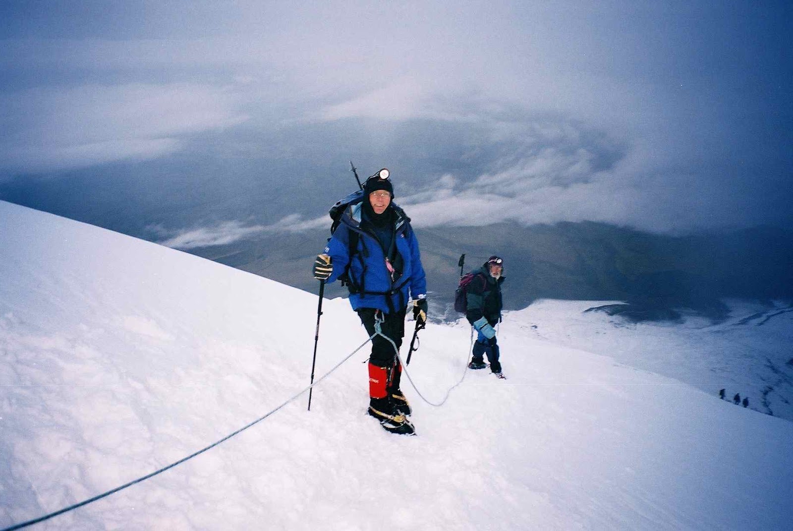
After a fitful night´s sleep we were up at midnight for a 0100 start. Nobody else slept either...much rustling of sleeping bags throughout the bunks. Ro was off an hour earlier than the rest of us in an attempt to compensate for her slow pace on the hill. We eventaully got going at 0115 into a relatively warm night with a clear sky and the lights of Cayambe and Quito in the far distance below us. As Smiler wanted us all to keep together in the early stages, giving the guides flexibilitry to move people between ropes and, if necessary, return with weaker members, it was a slow climb up the hill beside the refuge, with David B. particularly slow on the steeper sections and scrambles.
After about 1.5 hours we reached the glacier and put crampons on, roped up into groups – Robert and I with Pepe – and started the long trek up on to the Cayambe Glacier. Straightforward ground, with few crevasses and the clear sky occasionally crossed by shooting stars. There was lightning in the distance at regular intervals, reminding us that we were climbing the only glacier in the world crossed by the Equator! Ground steepening, we soon caught up with Mauricio and Ro, and two groups, ours and Abraham´s group, Steve and Matt, pulled ahead. Eventually Ro turned round, having reached 5000m and David S. went back with her. Smiler, Tim and Peter were the third team but were slower.
The glacier continued to steepen and by 0530 we were past a feature which the guides called ´The Island´, at about 5400m, and entering into more severely crevassed terrain with large seracs overhanging sections of the route. The last 200-300m was very steep and crossing the bergschrund involved front-pointing a 55-60 degree slope. This required a huge degre of effort from me as my lungs were now fit to burst. From about 5100-5200m my breathing had become very frequent, with one breath per step required – OK for a rythmic ascent on easier slopes but desparate when you are forced to stop for breath on really steep exposed ground that would best be climbed in a continuous movement. Pepe said that my breathing was a common altitude issue.
 |
| Colin and Robert on Cayambe |
 |
| Ascent of Cayambe |
 |
| Steepening slopes towards the summi |
 |
| Approaching the bergshrund below the summit of Cayambe |
 |
| Cayambe summit ice dome |
 |
| El Reventador erupting, from Cayambe |
 |
| Final approach to Cayambe summit |

 |
| On Cayambe summit 5790m |
 |
| Descending from the summit of Cayambe |
Tuesday 16 November
Late start at 1000 and into Cayambe to visit an internet café. Sent emails to Gillian and a couple of brewery people. Then south, mainly on the Panamericana before a late lunch at El Café de la Vaca near Machachi, 41 kms south of Quito. Increasingly cloudy during the day with some rain before lunch. Excellent meal in a building painted to look like a black and white dairy cow. Then north again before turning east in Machachi, taking a steepening and narrowing lane to an area at 3600m, crossing the paramo (Andean grasslands), more open rolling country with beef and dairy cattle and some barley. Farms en route were very basic, subsistence, almost hovels. Then late afternoon we turned into a very old hacienda, which still functions as a farm with 50,000 hectares. The Hacienda Hosteria El Porvenir, north west of Cotopaxi and just on the border of the national park, looked very basic from the outside, but inside it was cosy with log fires throughout and cinnamon tea (fortified by sugar cane spirit).
 |
| Cotopaxi from the Panamericana |
 |
| Hosteria El Porvenir |

Rooms in the roof were tiny, so opted to pay a huge $10 for a single room – two beds with a tiny gap in the middle, right under a sloping thatched roof, wickerwork walls and a curtain for a door. But this is a lovely, cosy, welcoming place. Dinner at 2000, then bed to rest for Cotopaxi in a couple of days time.
Pepe said today that we were acclimatised now – the key is now to rest and get the body into the best physical shape for Cotopaxi and Chimborazo. There is no more glacier training, so tomorrow we have a variety of less strenuous options to choose from.
Wednesday 17 November
Up and out at 0630 to get a view of Cotopaxi before the cloud build up. Magnificent vista across the paramo, with views to Cotopaxi rising like an ice dome from the grasslands. Good views in the opposite direction to Pasachoa, now resplendent in the early morning sun. Further across, the rocky summit of Volcan Sincholagua at ~4740m could be seen. I walked down the lane and took a few ‘arty’ shots of Cotopaxi before going up the hill behind the hostel for clearer sight of Cotopaxi.
 |
| Early morning light on Cotopaxi, from the Hosteria El Porvenir |
Llamas were grazing around the hacienda. Cinnamon tea, then we moved bags up to the 7-bed bunkhouse, where we were to spend the night. Then a rough muddy track steeply up from 3760m to 4600m, and we then walked up zigzags for 45 minutes to reach the Refugio Jose Rivas at about 4800m, a bright yellow building in the cloud which had built up steadily during the morning.
Lunch and some messing about before Smiler set off with David Baber and Ro for some more glacier training. We waited longer for Pepe with the cloud density increasing outside (with some sleet) and finally set off to reach 5000m for further acclimatisation. We yomped up to the start of the glacier in 30 minutes, up an ash track occasionally covered in fresh snow with big drops (unseen in the fog) to the right. Then nine minutes to get down, and then straight down the direct route to the car park in another ten minutes. We had left our climbing gear up at the hut in lockers. A rough descent – with our team again expressing concern about the mechanical condition of the bus – and got back to the hacienda just before 1700. Sorted gear for tomorrow and Friday, hot shower and write this log.
 |
| Cotopaxi from Hacienda Tambopaxi |
Thursday 18 November
Not a bad night’s sleep – earplugs helped to drown out Smiler’s snoring. At 0300 it was raining heavily – and that must mean snow up on the mountain. Up at 0630 and the clouds were covering the hill and light drizzle continued outside. A frustrating day was to begin. We delayed going up to the refuge as long as possible as it is cold and damp up there, but we eventually left, after reading the Mandela book for a couple of hours, late morning. A long slow crawl up to 4600m in the bus, which is getting increasingly beaten up on these roads. We spotted a colpeo (Andean Fox) on the way up.
Emerging from the bus with lighter sacs containing sleeping bag, duvet and clothing (as climbing gear had gone up the day before), we donned waterproofs as it was now lightly snowing in the dense cloud. We took the quick (but relentlessly upward) route to the hut. When we arrived it was relatively busy but we secured bunks in a spacious area, albeit that they were very narrow ones. Nobody had managed to climb Cotopaxi today, climbers having turned back at 5200m because of the snow. A long afternoon followed – cold, damp hut with no heating, so I sat around in my duvet jacket reading the Mandela book before dinner at 1800 and awaiting a decision at 1900 on tomorrow’s climb.
 |
| Expedition team at the Whmper Refuge below Cotopaxi |
 |
| Whymper Refuge, Cotopaxi |
Friday 19 November
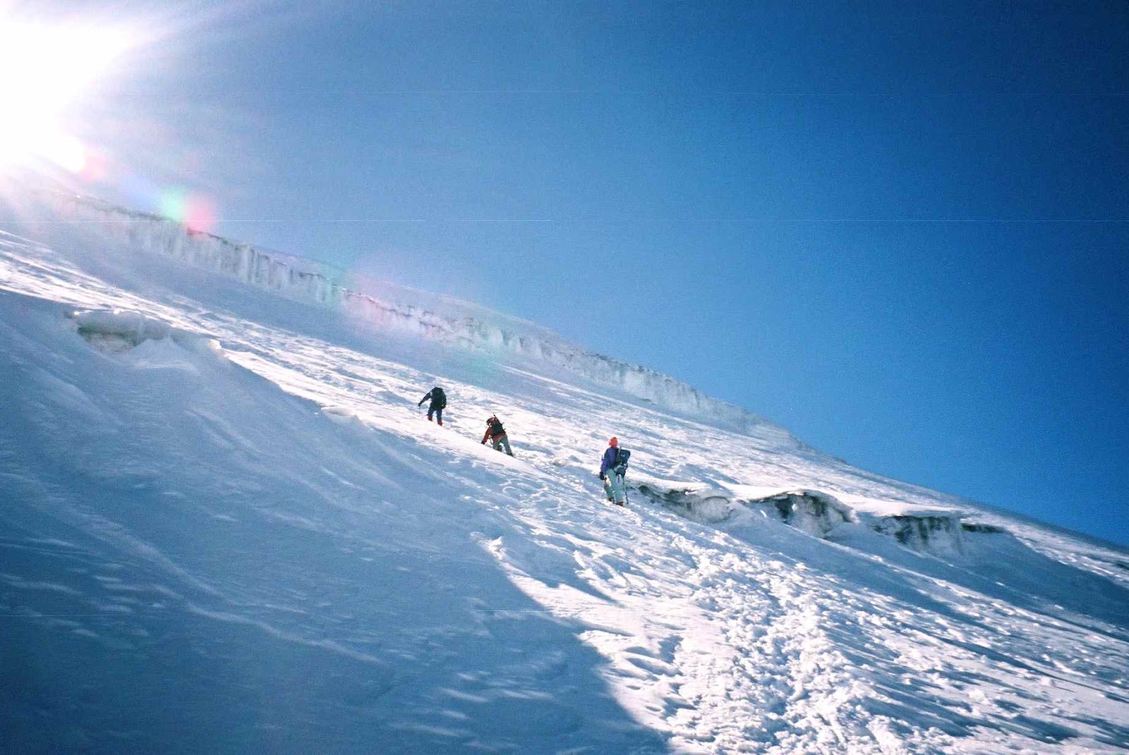
So the ascent began, the team of six with three guides making good progress up the ash path to the glacier, now mostly snow covered and crisp in the night air. After about 45 minutes we donned crampons and, still moving together, crossed some crevassed ground before hitting the first 400m of relentless 30 degree plus snow slopes, going almost directly up rather that zigzagging due to a potential avalanche risk following the recent snowfall.
Smiler and Ro, followed by new guide Daniel with David Baber, had broken trail but the snow was very soft in places, with foot placements already collapsing underfoot.
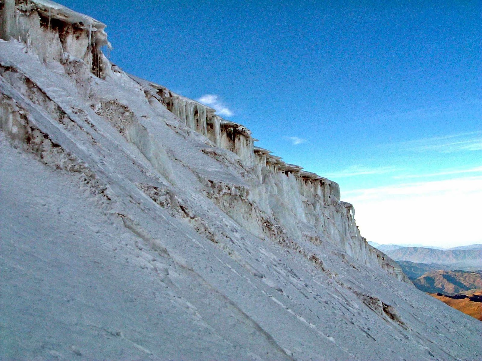
Some ground was more icy and we nevertheless made good progress. Surreal this, 0100 in the morning – lights of Quito in the far distance, a massive array of stars (and shooting stars again) with lightning lighting the sky to the east – Pepe said that this was the Upper Amazon basin. Roped to Pepe and Robert, as on Cayambe, we eventually started to meet even steeper ground, with the path winding intricately through massive crevasses and seracs – often the path was one foot wide, with massive run outs below.
 |
| Ice cliffs on Cotopaxi |
 |
| Waiting for dawn below the summit of Cotopaxi |

We had passed Ro and Smiler on the steep 400m section sometime before and a radio message confirmed that they had turned around at 5400m, Ro finding the soft snow very difficult to ascend.
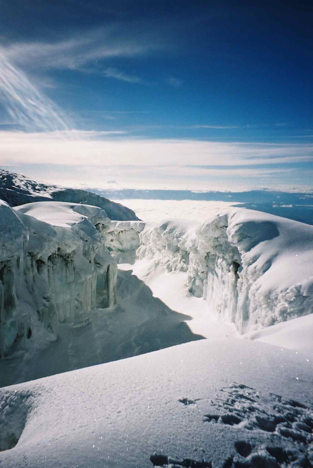
We sheltered next to a huge ice cliff from 0500 to 0530 and a number of other climbing teams, including Mauricio and David Baber, joined us to await the dawn. This disappointed as cloud had moved across the summit, so we descended back through the icefall and made a speedy descent to the refuge. This took us about 1½ hours, with a number of photo stops, mainly to capture the ice cliffs. As usual, I was absolutely bushed when we reached the hut, but with a breakfast of granola and yoghurt, followed by asparagus soup (!), recovered quite quickly.
 |
| Retreat from Cotopaxi |
 |
| Views on descent of Cotopaxi |

We waited, cold and damp, in the refuge for a couple of hours before descending to meet the bus and returning back to the valley floor, a two hour descent on really rough and muddy tracks following the recent rain.
 |
| After the aborted attempt on Cotopaxi |
 |
| Ruminahui with the paramo in the foreground |
 |
| Hotel Cuella de Luna |
Over dinner the previous evening we had collectively decided to ignore FO advice and go to Banos to see the erupting Tungurahua volcano. However, Jagged Globe would not permit this unless we all officially ‘signed off’ the trip as they could not cover the insurance liability. So, the original plan is back on, with a visit to Tigua, home of the naïve art seen earlier in the trip, plus a visit to the Quilotoa crater lake. Before we boarded the bus I managed to have a good chat with Gillian at home and that put me in a good mood for the day ahead.
We departed at 0830 and headed south on the Panamericana highway to the town of Latacunga. Normally, Cotopaxi would be resplendent to our left on this journey, but once again we were frustrated by a cloud base at 4500m that obscured everything. Latacunga was hectic, with a bustling market and narrow streets choked with people and cars. A couple of nice Piazzas with well tended gardens were seen, but the main objective was to get people on to the internet and find a post office. I replied to an email from Hayden and some ex brewery folks. Latacunga, by the way, has been destroyed three times by eruptions from Cotopaxi starting in 1742, the last one occurring in 1877. Some of the original buildings (well, the tops of) can be seen protruding from the now consolidated volcanic ash.
 |
| Central Highlands, Ecuador |
 |
| Tigua 'naive' art |

Then, after many more long hairpin bends, we reached the village of Zumbahua, which had a busy local market in full swing. This town has been completely rebuilt since 1996, following an earthquake (6.5 on the Richter scale). The village sits right on a massive tectonic fault, clearly visible as we left the village, yet they have rebuilt the place right on it again! Apparently fatalities were significant last time…
The people here are very poor, scraping a living from smallholdings, some with thatched shelters on the steep slopes that they farm. The elevation here is around 3700-3800m, but farming is very intensive and we saw many groups coming back from the market with donkeys and llama laden with goods and produce. The people here are predominately Quechua Indians, with the most common dress for the women a small suede trilby hat, a brightly covered poncho, knee length dress (often embroidered satin), and long white socks.
 |
| Zumbahua market |


From Zumbahua we climbed steadily to Quilotoa, a fairly touristy village on the rim of a volcano with a massive, green crater lake hundreds of metres below. A few photographs, then a simple lunch in a nearby hostel, during which time the clouds poured in, obscuring everything. So we passed an hour or so buying some cheaper local crafts, having fun bartering with the local Indians, then back to the hostel for some beer and chips whilst it hailed outside.
 |
| Quilatoa Crater Lake |
 |
| Local folk, Quilatoa |

Back on the bus at 1600 and 3 hours later we got back to the Hotel Cuella de Luna. A couple more beers, collected laundry, dinner and bed by 2130.
Pepe had said that we could expect another day of poor weather. Very similar to our arrival in Ecuador, there seems to be a pattern of three poor days, followed by three good days. We have experienced this cycle, with poor weather in Quito and on Pasachoa, improving when we did Pinchincha and good when we climbed Cayambe, before deteriorating again during our quest to climb Cotopaxi. With luck, the good weather window will appear for our attempt on Chimborazo, Ecuador’s highest mountain, late on Monday night into Tuesday morning.
Sunday 21 November
Another R&R day (rest and relocation!) with a 1000 departure to Urbina, just to the southeast of Chimborazo. The destination for the night is Pasada La Estacion, a converted train station built in 1905. At 3618m our acclimatisation continues! We travelled south on the Panamericana again, passing once more through Latacunga and then eventually arriving at Ambato, a thriving but unattractive town 136 kms south of Quito. A quick visit to an internet café, then a lunch of pizza, chips and beer (very healthy!), before travelling a little further south to Urbina, which feels about as remote as you can get. Pasada La Estacion stands isolated next to a railway track (Quito to Riobamba), which has now fallen into disrepair. Kids from a nearby farm posed for photos in return for sweets, whilst kids of about 12-13 rode past on horseback, herding mixed groups of cattle and llamas.
 |
| Kids at Urbina |
 |
| Paramo below Chimborazo |
 |
| Pasoda La Estacion, Urbina |
 |
| Sunset on Chimborazo |
We had a convivial dinner of trout (with some good Chilean wine), preceded by some local musicians with a variety of guitars, drums and pan pipes. Entertaining but a bit touristy! Bed by 2115.
Monday 22 November
Not a bad night’s sleep. Awoke to cloud on Chimborazo, surprise, surprise. Dry lips again – Pepe had remarked that we would notice a big difference in humidity as we went further south and west. Today’s plan is to pay a quick visit to Riobamba, then up to the Carrel Hut at 4860m for lunch, then a walk up to the Whymper refuge at 5000m for our short overnight before attempting Chimborazo overnight. So we did just that, with an interesting drive into the Chimborazo reserve, a good road almost all the way up to the Refugio Hermanos Carrel, named after the Swiss Carrel brothers who guided Edward Whymper on the first ascent of Chimborazo in 1880). The terrain here is very desolate, quite a lot of rock fall and minor landslips on the road, with the earth mainly volcanic ash, broken only by sparse shrubs. We sighted vicunas (a wild relative of the llama) en route. We had lunch at the Carrel hut, before humping our gear 1 km further up the hill to Refugio Whymper at 5000m.
 |
| Chimborazo 6310m |
 |
| Carrell Refuge 4860m |
 |
| Chimborazo from the Carrell Refuge |
 |
| Refugio Edward Whymper, 5000m |

 |
| Hut life! Whymper Refuge at 5000m |
Tuesday 23 November
Awoke to clear skies and a good moon, which afforded some natural light. As before, Ro and David had gone off an hour earlier with Pepe to give them a head start and Robert and I had been allocated the ebullient Mauricio as our guide this time. An early start up a good track across ash moraine, before the path steepened and entered an unpleasant boulder field, with icy patches on the path. Eventually we cramponed up and climbed a small glacier that drops from the narrow ridge above (by this time we had already passed Ro and David, who were to turn back shortly after). The glacier steepened and we had some route finding to do through some seracs before rising on to the narrow ash ridge with steep drops on either side.
 |
| The tricky initial glaciated section of the Chimborazo climb from the Whymper Refuge, seen in daylight. Much more difficult in the dark! |
 |
| On the ridge to Chimborazo, about 2 a.m. |
 |
| Shadow projected by Chimborazo at sunrise |

 |
| Stumpy struggling up Chimborazo |
 |
| Ice cliffs below Chimborazo summit |
 |
| Ridge to Chimborazo summit |
Views from the summit were marvellous and we enjoyed blue skies there. On the way up we had taken photos of the shadow of the volcano projected over the country to the west as the sun was rising. We were now standing at 6260m (just below the tricky Whymper summit) and at well over 20,000’ this is the highest I’ve ever been in the mountains. Moreover, as the highest mountain in Ecuador, it is also the furthest point from the centre of the earth due to the earth’s ‘Equatorial bulge.’ We stayed on the summit for 30 minutes, taking photographs and enjoying the views. We could see almost all the main volcanoes in Ecuador, with the exception of Tungurahua which was obscured by the Whymper summit. To the north we could see the Illinizas, Cayambe, Antisana, Cotopaxi (all poking through the clouds) and to the south, Volcan Sangay, with smoke and ash plumes rising from it. The top was very crevassed giving interesting ice scenery, but was broad enough to walk around unroped in comparative safety.
 |
| Mauricio and Colin on Chimborazo summit, 6260m |
 |
| Summit crevasses, Chimborazo |
 |
| View to the Whymper summit on Chimborazo 6310m |
 |
| Cotopaxi from the summit of Chimborazo |
 |
| Summit views from Chimborazo |
 |
| Stumpy on the Veintemilla summit of Chimborazo 6260m |
 |
| Descent from Chimborazo |

 |
| Snow slope above the Whymper Refuge (seen far below, left of centre) |

 |
| View down to Whymper Refuge (the tricky bit!) |
 |
| Final section of main Chimborazo ridge |

We set off for Quito just after noon, taking a different road out of the reserve to rejoin the Panamericana northbound at Ambato. The local Indians herd sheep in this barren area and are a different tribe, with both male and female wearing straw boaters rather than the trilby seen elsewhere. A long ride back, 4 ½ hours.
Hotel in Quito as before, unpack clothes to dry, then a few beers before finding a good little Mexican restaurant two blocks from the hotel. Good dinner, bed by 2130.
Wednesday 24 November
Breakfast at 0830, then with Robert and Smiler to nearby bookshop to see if I could get a tome on the geomorphology of Ecuador. No luck, so I took a cab to the Instituto Geographica Militar as recommended by the bookshop. This turned out to be a military facility and after explaining what I was after, left a copy of my passport at the gate house and a soldier escorted me to the ‘Marketing’ department where maps were for sale. I was then taken to another area but no English language books were available, so I returned to the hotel by cab, a $5 round trip including wait time. Went to a nearby internet café to check email and start typing this log before lunch with Robert in a nearby fish restaurant, Las Redes, which offered the Ecuadorian speciality ‘ceviche’, a selection of marinated raw fish. This was excellent and a pleasant hour or so was had.
Then back to the internet café until 1700, a dash through the rain and down to a group meeting at 1730. After discussing and agreeing tips for the guides, Robert presented Smiler with a book on the Andes of Ecuador and we then repaired to the bar for the last time. Javier joined us, followed by Pepe and his family. Pepe’s wife comes from the jungles to the east, six hours away by road plus three hours by boat.
After several false starts we ended up in the Namaste Everest restaurant, and despite very slow service, we had a good meal washed down with quite a lot of beer and wine. Cost only $12 each!
 |
| Last night in Quito |
Thursday 25 November
Up at 0620 and homeward bound. Apparently, it was 0230 when we got back last night…! And it feels like it…. Ro was very hungover, but David Baber came down to see us off and David S. was soon back on the beer on the plane, having a Heineken with his breakfast!
Uneventful flight home, but noisy Germans and Dutch restricted sleep. Home by 0945.
No comments:
Post a Comment