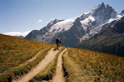
Travelling companions: Richard Pratt and Hayden Measham. Self guided and accessed via Grenoble.
Guide books: Tour of the Oisans by Andrew Harper, and The Ecrins National Park by Kev Reynolds (both Cicerone Press).
Day 1
We climbed up into the narrowing valley with a quick refreshment break at the Gite d’Etape above Combe Haut, followed by a long plod past the Cabanes de Sarenne and Col de Sarenne (1999m), arriving at 1400.
Lunch stop here with big views down into the Ferrand valley and the village of Clarans le Haut, some 600m below our feet. It was a lofty perch for lunch.
 |
| View from Col de Sarenne 1999m |
A short descent took us to a river crossing across a footbridge, before the final steep pull up a shaly ridge to Besse at 1530m, our final destination, arriving about 1700. Super little village with nice hotel, Hotel Alpin, with friendly young hosts. Good crepes and Kronenbourg rounded off the day!
 |
| Hotel Alpin, Besse |
 |
| Start of day 2 |
 |
| Ascent to Col Bichet |
 |
| Moorland crossing to Col Souchet |
 |
| Northern edge of the Ecrins |
 |
| Towards la Meije |
 |
| Path down to le Chazelet |
 |
| GR54 to le Chazelet |
 |
| Valle de la Romanche |
 |
| la Grave, Ecrins National Park |
Day 3
A long day ahead! We left the village after buying some pizza for lunch, getting on our way by 0850. Dropped down to the river, then followed a contouring path through the woods before going more steeply up through the woods to cross the ridge high above the valley, climbing to 1756m on a very quiet path.
 |
| Ecrins National Park |
 |
| Zigzags en route to Col d'Arsine |
 |
| Refuge de l’Alpe de Villar d’Arene (2077m) |
 |
| Glacial lakes below Col d'Arsine |
 |
| View back on day 3 from le Casset |
We had a slow start as the hotel breakfast only available form 0800…very late for the walking fraternity! Finally got going at 0850, walking across the wrong bridge (Hayden had the map though!!) and crossing over pastureland before climbing up steeply rising woodland tracks for three hours to reach the Col de l’ Eychauda (the last 45 minutes on unpleasant gravel ski lift service roads). An unattractive col, though with big views to the east and west in very hot and dry conditions.
 |
| View from descent after Col de l'Eychauda |
 |
| Horrible little path to Ailefroide |
Day 5
Started at 0830 with the simple objective of climbing up to the Refuge Cezanne, now known as the Refuge de la Pre de Madame Carle, at 1874m. A very easy walk, some on the road but mostly on a rough, overgrown track. After a coffee we set off for the Refuge Glacier Blanc (can’t keep a good team down!) and zoomed up easy zigzag paths to 2380m where we decided we wouldn’t have time to get to the refuge, have lunch and get down in time for a taxi already booked to get us down the valley to our penultimate overnight stop at Vallouise. So, we had a quick stop on the smooth, striated granite blocks overlooking the snout of the fine Glacier Blanc and in sight of the refuge 250m above.
 |
| Glacier Blanc |
 |
| Barre des Ecrins above Glacier Neige |
 |
| Glacier Blanc |
Taxi down to Vallouise where we checked into the Hotel le Vallois. Pleasant enough village with a brew pub and some unusual chalet architecture, with many levels (hay lofts) and use of stone arches on the lower elevations (but we’re now only 50Kms from Italy).
Day 6
Now out of season, so forced to take an early taxi to Briançon and managed to check in to the hospitable Hotel Edelweiss, just below the historic old fortified town.
Impressive town, worth a visit, a decent lunch at a restaurant overlooking the valley to the north of the town and all was well with the world!
 |
| Briançon |
A more challenging route than the Tour du Mont Blanc, with some long days and, to the north, more shaly slippery paths than were expected.
We only did the opening sections of the GR54 and it gets more challenging later in the route, with some very long, isolated days with mountain refuges the only overnight options. But we’ll be back…the area is unspoilt, virtually undiscovered by the wider walking community (most Brits going to the Ecrins will be going to rock climb), and spectacular.