I travelled on a section of ‘Discover Chile’ (also part of the ‘Hiking in a Thin Country’ tour) operated by Exodus in conjunction with their local agents Travel Art in Santiago and Geo Tours in San Pedro de Atacama.
Days 1 and 2
After 11.5 hours on a BA flight (out of date films, noisy cabin staff) to Sao Paulo in Brazil, first light brought dramatic views on the final approach, mist shrouded valleys and gentle hills, before the vast metropolis came into view. Urban sprawl as far as the eye can see, with row upon row of high rise apartments rising from the mist like gravestones in some vast war cemetery.
Sao Paulo sits just south of Rio de Janeiro on the Atlantic coast, but that’s about all I know about it, and a couple of hours later I was aloft again, this time on a crowded TAN 777 bound for Santiago, the capital of Chile, four hours over Brazil, Uruguay and Argentina, with the last 45 minutes of the flight passing over dramatic Andean scenery. Mountains soaring to over 6000m, volcanic cones, glaciers and huge expanses of empty space, just my kind of country!
Santiago airport is modern and efficient and, apart from the attention of a few dodgy taxi touts, and then a taxi that ran out of petrol, I found my bed for the night, the nearby Hotel Diego de Almagro.
I had a short business visit to make in the upmarket area of Providencia before an ‘express tour’ of Santiago, facilitated by the delightful Valentino, a guide that Exodus have used over the years on their Chilean tours.
In a very pleasant 30 degrees, dry with a slight breeze, we dashed through the Centro area, first visiting Mercado Central, a bustling and very touristy fish market complete with a multitude of restaurants all plying for trade. Then on to the Plaza de Armas, the heart of the city, bounded on one side by the externally understated Catedral Metropolitana, a neo-classical structure, damaged and subsequently repaired after the 1985 earthquake, and magnificent inside with piped choral music tastefully engendering just the right atmosphere. Hey, but no time for spirituality…on past the various central museums and the Palacio de la Moneda, the presidential office, and the fine Centro Cultural Palacio La Moneda, under which there is a vast cultural exhibition hall, at the time of my visit hosting the roaming Terracotta Soldiers exhibition.
We dropped into the busy Ave. San Antonio, bounded at one end by the oldest colonial building in Santiago, the Iglesia de San Francisco, and stopped to visit Hotel Galerias, a fine and well located spot, with a restaurant serving fine Chilean food.
A final drive through the bohemian district of Barrio Bellavista, just south of the raging Rio Mapucho, the glacier fed river that bisects the city, and the hill parkland of Parque Forestal. Home of the poet Pablo Neruda, this area features many brightly painted buildings set in leafy cobbled streets, with many bars and restaurants, set to come alive later in the day.
Alas, that’s all I had time for, so back to the hotel, a quick dinner of conger (a local favourite, firm meaty fish with a delicate flavour), cooked in a pleasant sauce, and early to bed for the flight in the morning.
I like Santiago, for a city of 6 million (in a country whose population is fast approaching 17 million), it had a purposeful but relaxed air about it, not spectacularly endowed with great sights, but with sufficient history and green spaces to occupy a day or two of anyone’s time. February is a good time to visit - it’s dry and very warm, the famous winter smog is not present and many people have gone to the coast for their summer break. Bounded by the Andean foothills to the east, this is a beautifully situated city with pleasant and accommodating residents.
Day 3
A crack of dawn start to catch the LAN flight to Calamar, the town that the Lonely Planet guide brutally calls a ‘shithole’, a town which acts as a gateway to a vast copper mining area (copper accounting for a third of Chile’s exports, now mainly to China, and a key source of Chile’s relative wealth compared to its neighbours). Incidentally, LAN service is great and the departure desks and security at Santiago’s airport are as efficient as I’ve seen. Well done Chile…you put the UK to shame.
The sun rose as we ascended on our 1000km northward track, with the summit of Aconcagua, South America’s highest summit at 6959m, dominating the skyline as the sun rose directly behind it.
Calamar is also the gateway to my base for the next four days, the small town of San Pedro de Atacama, 106km to the south east. With my guide Francisco, we took a couple of hours or so to reach San Pedro de Atacama, literally an oasis in an otherwise hostile desert, said to be the driest in the world.
Getting to San Pedro had us cross two minor mountain ranges, rising over 3000m, the Cordillera de Domeyko and the Cordillera de la Sal, home of the popular Valle de La Luna (Valley of the Moon), just west of the town. A photo stop here, looking to the oasis of San Pedro to our east, and the gigantic salt pan, Salar de Atacama to the south. Barren, desolate, beautiful. The final stretch of road into San Pedro takes you through the imaginatively named Valley of Dinosaurs, after the weird rock formations straddling both sides of the road.


San Pedro is a town of some 5000 people at an altitude of 2440m, and had a very laid back feel, popular with lots of the younger backpacker brigade who thronged the main street.
My home for the next four nights is La Casa de Don Tomas, 10 minutes walk from the town centre. We took a quick walking tour of the town, first visiting the very well designed Museo Arqueologico, established by a Belgian archaeologist Gustavo Le Paige and now run by the University of North Chile. A capable English-speaking guide Carla took us through the history of the area, in a cleverly presented format. Then on to pay a visit to the tiny church of San Pedro, with adobe walls and a ceiling constructed from cactus wood mixed with mud and straw. We completed the morning’s exertions with a yomp up to see the fortress 3km out of town, the Pukara de Quitor, constructed by the indigenous groups of the area before the Incas arrived and later the scene of fierce battles with the Spaniards when they arrived in 1540, unfortunately the locals losing out and promptly beheaded by their victors.
Views from the top of the fort afforded fine views to the nearby Licancabur (5916m), a perfect conical volcano, one of many towering over the desert to the east of San Pedro and forming the border with Bolivia and Argentina. Some are still active, one in view to the south, erupting back in 2006.
A lunch in town, a good steak at Milagro, and then off at 1630 to walk some parts of the nearby valleys, firstly the ‘Valley of Death’, Valle de la Muerte, misnamed after the Le Paige wrongly pronounced the name at an inauguration ceremony, when he had intended to call it Valley of Mars. This was thronged by many people enjoying the spectacular rock scenery, but numbers dwindled as we descended the long sandy trail, before watching a number of folk sand-boarding the giant sand dunes to our left.


Then into the popular Valley of the Moon area, first taking a trail very few use, initially descending a giant sand dune before threading our way through a narrowing defile called Salt Canyon, with some truly amazing rock features showing rain and wind erosion of the clay lining the canyon sides.
After this, with the evening light starting to subside, we visited the Tres Marias, three eroded rock stacks adjacent to an old salt mine, then back to the small summit overlooking the huge sand, clay and salt walls of the Amphitheatre, before climbing the largest dune in the reserve to establish a spot for watching the sunset. Normally, skies over the Atacama are crystal blue, but today had seen a lot of cloud build up, caused by bad weather over the Bolivian highlands, and this was to provide the formula for the most spectacular sunset I have ever seen.
We climbed south along a long ridge to get away from the massed crowds, and although at one point we thought that the sun would gently die away for the day, once below the horizon, the whole view was magnificently transformed. With mushroom like clouds on the volcanoes to the east, looking like a form of nuclear explosion, in pink hue, the rocks around us glowing a golden yellow and the sky to the west exploding into bright gold, then pink and finally a deep red, this was a moment of natural glory. Indeed, my guide Francisco, said that it was the finest he had ever seen. What a way to end the day!


Day 4
Today was spent in the environs of the Salar de Atacama, a huge salt lake formed by the evaporation of salt from water collecting in a high basin from the mountains and volcanoes to the east. Apparently, the depth of the salt pan is 1.5km! It is largely unaffected by man, being a refuge for rats, lizards, numerous bird species and three varieties of flamingo who feed off small shrimps that themselves depend on algal growth in the lagoons on the salt pan.
Driving southeast from San Pedro, I was pleasantly surprised to see overnight snow on the chain of volcanoes running south for as far as the eye can see. We passed the new Alma telescope array (64 of them planned), an international astronomy project set to exploit the normally crystal clear skies of the Atacama. This is a huge project on the slopes of Chagnantor, although somewhat close to the ominous mass of Volcan Lascar (5154m), which has erupted many times in recent history, the latest back in 2006. Rather like the people of Chile, Chilean volcanoes erupt slowly, no explosive activity here, and then rain ash all over Bolivia and Argentina! For an hour or so, we cruised on good tarmac looking for wild donkeys, llama and vicuna, who live at this altitude on alfalfa grass and various salt bushes. Then, turning west through the rich farming village of Toconao, we headed for Laguna Chaxa in the National Reserve Los Flamencos at an altitude of 2300m.
Walking across the saltpan towards the lagoons, we were able to study the various forms of crystallisation, with chlorides forming flowers up to 70cm high and sulphates giving level surfaces. Lithium is mined further south on the Salar, using an evaporation process.
Only Andean Flamingo were seen on the day, in small groups albeit with some in flight overhead. I love saltpan scenery, desolate, intricate surfaces, and a shimmering light above the pan, offset by volcanoes in the far distance and the huge skies that abound in this part of the world.
We departed as big tour groups headed our way, an unfortunate consequence of the Chilean authorities’ scheme to limit the human touch points of their environment, rather than risk uncontrolled wandering by visitors and the potential damage they might then cause.


Heading south again, we steadily climbed above 3000m, with big views back to the Salar, before our day was disrupted by a front tyre puncture. After half an hour or so, my guide Francisco hitched a lift with another tour bus, leaving our hapless driver Julio to wait for rescue (moral of the story…carry a spare!).
Our objective this time was to visit Laguna Miscanti and Laguna Miniques, at around 3900m, both surrounded by nearby mountains and volcanoes, the most prominent being Cordillera Miniques at 5910m.
Air was somewhat thinner here, but a good yomp along one lake side and over a hill to the other provided some good exercise. But it’s amazing how quickly you dry out at this altitude and in the local climate. Litres of water needed!


We were returned to the village of Socaire for lunch, a pleasant spot populated by indigenous people, who still farm the terraces introduced by the Incas, growing quinoa, some corn and potatoes.
Then Julio joined us, with vehicle newly shod, for our return to San Pedro, with a quick stop off in Tocanao to look at the quaint little church in the village centre. This has a distinctive bell tower set away from the main church building….apparently the bell tower represents the male, the church itself the female. This pearl of information included just in case you didn’t know that!
The final stages of our journey were then enlivened by many dust devils, a result of intense local heating close to the saltpan, creating small tornados filled with dust. They usually appear very quickly, whirl about a bit, then die as the energy dissipates. But don’t say that to our driver Julio, who’s home interior was covered in dust recently, having left a door open that just happened to be in the path of the devil!
Another day of contrasts then, to be followed tomorrow by a 0430 start to see sunrise at the El Tatio geysers.
Day 5
0430, joining a convoy of fast moving tourist buses already on their way to see sunrise at the Tatio geysers (the highest geyser field in the world), a couple of hours away…it felt a bit like the torchlight procession on Mont Blanc, but without the effort!
We travelled on a mixture of surfaces, but the journey was mainly on the heavily corrugated principal road that all buses seem to use for the journey there, speeding their 90km ascent from San Pedro at 2440m to over 4300m at El Tatio. This road passes across very wide sand and clay plains at higher elevations, so it was not uncommon for buses to make their own road across, and we were frequently 4 or 5 vehicles abreast as we speeded though the fog and dust of pre-dawn. Surreal.

We arrived at the entrance station at 0615, shaken but not stirred, and passed through the madding crowd to reach the geyser basin under the brooding cone of Volcan Tatio, 5215m.
In the emerging light, we observed a variety of geyser types (allegedly 64 of them), some erupting at regular intervals, others randomly spewing, whilst the rest were content to steadily steam away. There were many people here today, although sometimes it can be deserted, so pictures swiftly taken and a quick breakfast before heading away from the crowds into the head of the basin to watch vicunas and attempt to spot a long tailed rabbit called a vizcacha.


Then back to the exit gate with a quick dip in the crowded thermal pool to warm frozen bones as we had been standing around in sub zero temperatures before the sun deigned to rise above the mountains.
As we waited at the exit gate we happened across a group of young Chileans whose car had left the road about a mile away, the consequence of a moment’s lapse of concentration by the driver. Bruised and a bit battered, we offered them a lift back down to San Pedro, a gesture gratefully accepted.
We returned by a different route, avoiding the majority of tour buses that roared their way back to San Pedro. Our route was a dramatic one, with huge vistas over the high altitude desert in the immediate vicinity of the volcanoes, which stretched as far as the eye could see, one with summit fumeroles spewing gases backlit by the rising sun. Multi coloured layers of sand, ryholitic rocks and basalt lava flows, with the welcome addition of small herds of vicuna with young, one elusive vizcacha, and one distant sighting of the rare rhea, an ostrich-like bird.


It was a long way down. My fingers had tingled at El Tatio, a normal symptom of rapid ascent to higher altitude that I usually get, although this quickly dissipated as we headed down this road. But, even at 3600m, when we stopped at a small laguna straddling the road, breathlessness soon curtailed the normal rate of exertion.
Our next destination was the thermal springs of Puritama, situated in a box canyon 34km from San Pedro, accessed in our case by a pleasant hour exploring the canyon, the lower reaches of which feature large cacti which seem to cling on to the precipitous cliff walls with virtually nothing to secure them. The whole canyon, and the valley in which the commercially run hot springs are situated, is vegetated with the ubiquitous brea bush and large stands of pampas grass straddling the fast flowing stream, full of tiny fish in the luxuriant 33.5 degrees temperature. Many locals were bathing in family groups below the commercial operation, but we did our bit for the local economy and used the latter, complete with changing rooms, platforms adjacent to the numerous pools and waterfalls. Very well done indeed, not too busy, and a nice spot to chill (well, actually to warm) in the midday sun.

Then, down, down, down, all the way to San Pedro, with massive views of the Salar to the south, and the now familiar chain of volcanoes disappearing into the haze. Well, all but one. The rather cheeky Volcan Lascar, still resplendent with snow from a highly localised overnight fall, almost saying ‘look at me’ in the early afternoon heat.
I avoided the temptation to jump on another five hour tour to Laguna Verde, just over the border in Bolivia: too much of a good thing for one day, and with a sky back to its normal crystal blue, it was very hot indeed by now.
A quick lunch at La Estaka, with brusque but brisk service the order of the day, then a well-earned afternoon nap!
Day 6
What a day! The best yet. An illegal soiree into Bolivia, a snap decision to go off road to visit the very remote Salar de Tara, sandwiched between Bolivia and Argentina in a small niche of Chile, and close ups of vicuna and James Flamingo.
We set off late today, heading directly east on the tarmac towards the Argentinean border and straight for the towering cone of Licancabur piercing into bright blue skies. To our south was Volcan Lascar showing off again, this time with a trail of steam and gas emanating from its summit in the cold morning air.
A long slog up hill, passing the left turn to Bolivia and then a surprise! I’ve always wanted to see Laguna Verde in Bolivia, and there it was, some 15km to the north. I wanted a closer view, so we headed off the road across the desert, into Bolivian territory (naughty, naughty) and were rewarded with fabulous views of Laguna Verde and the ‘white lake’ to its right. During the day, when the wind picks up, green minerals in the left hand side of the lake migrate across much of the lake, giving the reason for the name.


Then back to the highway, shared with trucks moving goods from the Chilean coast into Argentina, Paraguay and Brazil, but we had the road to ourselves for most of the time. Still climbing, we eventually reached the highest point of the road, at 4806m, just 2m short of the highest mountain in W. Europe, Mt Blanc.

The land here is mainly a light brown coarse sand desert, with volcanoes all around and the occasional laguna, fortunately the first one we happened upon complete with a herd of vicuna, affording close up shots.
Further on, some 40km from the Argentinean border, we passed the Salar Pusja (an important breeding site for the James flamingo), before turning off to visit the ‘Monks of Pacana’, large pointed cliffs and naturally formed rock sculptures resembling a procession of monks. Like their namesakes on Easter Island, they are also known as the ‘Moais of the Desert’.


My guides then had a brainwave. Even though they’d never visited before, and only vaguely knew the way (we ended up following distant dust trails of a couple of other 4WDs), they suggested we visit the remote Salar de Tara. I readily agreed, always one for a proper adventure, and after an hour of very hard driving across the desert, with numerous ravines to cross, we were rewarded by the most amazing sight…a huge lagune, bordered by a brilliant white salt pan to the right and snow capped volcanoes to the left. Our approach took us past lava fields and some amusing sandstone rock formations (think of the ‘finger’!).
We virtually had this enormous space to ourselves, except for Andean and a couple of James flamingos that were feeding voraciously on our side of the lake. Lunch here, after a few hundred photos (!), then we took a rocky ravine out of the pan, again with marvellous rock architecture.


A long drive back across the desert to our start point, this time with no dust trails to follow, but soon back to the Monks of Pacana before rejoining the main road back to San Pedro. A beautiful afternoon, the blue sky enlivened by some high level clouds and we were to be entertained by a very young vicuna who had decided to run along the road beside us. Clearly separated from its mother and disorientated, Francisco and Julio gently captured the animal and walked it across the desert to rejoin the herd at a small laguna. Alas, this little thing really had a death wish, as no sooner had Francisco put it down near the water, then it ran off again in the opposite direction to the herd. Sad.

The final stage of the journey was uneventful, another huge descent, about 2000m in one go, to San Pedro, and one again safely ensconced in the hotel for my final night in the region.
Day 7
An early start to Calama to fly to Buenos Aires via Santiago. On the drive down from San Pedro, the clear night sky revealed masses of stars, before we spotted the distant lights of Calamar and the big copper mines nearby, the latter visible about 50km away. Once again, LAN made the process effortless at the airport.
Summary
It’s a long way to Chile from the UK, and not cheap by South American standards, but it’s certainly worth a visit. On this trip I only covered a tiny area of Norte Grande, the northernmost part of Chile, but found it truly spectacular in terms of scenery and the infrastructure and friendliness of local people are commendable. Even the loos in national park sites and small restaurants are kept spotlessly clean.
Do come and discover Chile for yourself, but try to do more than visit the normal tourist honeypots. Although sights like the Valley of the Moon and the Tatio geysers are splendid, they attract hordes of visitors and they tend to be concentrated in very small areas. Get off the beaten track, and bribe your guide to take you to the Salar de Tara!
 |
| Sunset over San Pedro de Atacama |
After 11.5 hours on a BA flight (out of date films, noisy cabin staff) to Sao Paulo in Brazil, first light brought dramatic views on the final approach, mist shrouded valleys and gentle hills, before the vast metropolis came into view. Urban sprawl as far as the eye can see, with row upon row of high rise apartments rising from the mist like gravestones in some vast war cemetery.
Sao Paulo sits just south of Rio de Janeiro on the Atlantic coast, but that’s about all I know about it, and a couple of hours later I was aloft again, this time on a crowded TAN 777 bound for Santiago, the capital of Chile, four hours over Brazil, Uruguay and Argentina, with the last 45 minutes of the flight passing over dramatic Andean scenery. Mountains soaring to over 6000m, volcanic cones, glaciers and huge expanses of empty space, just my kind of country!
Santiago airport is modern and efficient and, apart from the attention of a few dodgy taxi touts, and then a taxi that ran out of petrol, I found my bed for the night, the nearby Hotel Diego de Almagro.
I had a short business visit to make in the upmarket area of Providencia before an ‘express tour’ of Santiago, facilitated by the delightful Valentino, a guide that Exodus have used over the years on their Chilean tours.
In a very pleasant 30 degrees, dry with a slight breeze, we dashed through the Centro area, first visiting Mercado Central, a bustling and very touristy fish market complete with a multitude of restaurants all plying for trade. Then on to the Plaza de Armas, the heart of the city, bounded on one side by the externally understated Catedral Metropolitana, a neo-classical structure, damaged and subsequently repaired after the 1985 earthquake, and magnificent inside with piped choral music tastefully engendering just the right atmosphere. Hey, but no time for spirituality…on past the various central museums and the Palacio de la Moneda, the presidential office, and the fine Centro Cultural Palacio La Moneda, under which there is a vast cultural exhibition hall, at the time of my visit hosting the roaming Terracotta Soldiers exhibition.
We dropped into the busy Ave. San Antonio, bounded at one end by the oldest colonial building in Santiago, the Iglesia de San Francisco, and stopped to visit Hotel Galerias, a fine and well located spot, with a restaurant serving fine Chilean food.
A final drive through the bohemian district of Barrio Bellavista, just south of the raging Rio Mapucho, the glacier fed river that bisects the city, and the hill parkland of Parque Forestal. Home of the poet Pablo Neruda, this area features many brightly painted buildings set in leafy cobbled streets, with many bars and restaurants, set to come alive later in the day.
Alas, that’s all I had time for, so back to the hotel, a quick dinner of conger (a local favourite, firm meaty fish with a delicate flavour), cooked in a pleasant sauce, and early to bed for the flight in the morning.
I like Santiago, for a city of 6 million (in a country whose population is fast approaching 17 million), it had a purposeful but relaxed air about it, not spectacularly endowed with great sights, but with sufficient history and green spaces to occupy a day or two of anyone’s time. February is a good time to visit - it’s dry and very warm, the famous winter smog is not present and many people have gone to the coast for their summer break. Bounded by the Andean foothills to the east, this is a beautifully situated city with pleasant and accommodating residents.
Day 3
A crack of dawn start to catch the LAN flight to Calamar, the town that the Lonely Planet guide brutally calls a ‘shithole’, a town which acts as a gateway to a vast copper mining area (copper accounting for a third of Chile’s exports, now mainly to China, and a key source of Chile’s relative wealth compared to its neighbours). Incidentally, LAN service is great and the departure desks and security at Santiago’s airport are as efficient as I’ve seen. Well done Chile…you put the UK to shame.
The sun rose as we ascended on our 1000km northward track, with the summit of Aconcagua, South America’s highest summit at 6959m, dominating the skyline as the sun rose directly behind it.
Calamar is also the gateway to my base for the next four days, the small town of San Pedro de Atacama, 106km to the south east. With my guide Francisco, we took a couple of hours or so to reach San Pedro de Atacama, literally an oasis in an otherwise hostile desert, said to be the driest in the world.
Getting to San Pedro had us cross two minor mountain ranges, rising over 3000m, the Cordillera de Domeyko and the Cordillera de la Sal, home of the popular Valle de La Luna (Valley of the Moon), just west of the town. A photo stop here, looking to the oasis of San Pedro to our east, and the gigantic salt pan, Salar de Atacama to the south. Barren, desolate, beautiful. The final stretch of road into San Pedro takes you through the imaginatively named Valley of Dinosaurs, after the weird rock formations straddling both sides of the road.


 |
| Views on the way to San Pedro de Atacama |
My home for the next four nights is La Casa de Don Tomas, 10 minutes walk from the town centre. We took a quick walking tour of the town, first visiting the very well designed Museo Arqueologico, established by a Belgian archaeologist Gustavo Le Paige and now run by the University of North Chile. A capable English-speaking guide Carla took us through the history of the area, in a cleverly presented format. Then on to pay a visit to the tiny church of San Pedro, with adobe walls and a ceiling constructed from cactus wood mixed with mud and straw. We completed the morning’s exertions with a yomp up to see the fortress 3km out of town, the Pukara de Quitor, constructed by the indigenous groups of the area before the Incas arrived and later the scene of fierce battles with the Spaniards when they arrived in 1540, unfortunately the locals losing out and promptly beheaded by their victors.
Views from the top of the fort afforded fine views to the nearby Licancabur (5916m), a perfect conical volcano, one of many towering over the desert to the east of San Pedro and forming the border with Bolivia and Argentina. Some are still active, one in view to the south, erupting back in 2006.
A lunch in town, a good steak at Milagro, and then off at 1630 to walk some parts of the nearby valleys, firstly the ‘Valley of Death’, Valle de la Muerte, misnamed after the Le Paige wrongly pronounced the name at an inauguration ceremony, when he had intended to call it Valley of Mars. This was thronged by many people enjoying the spectacular rock scenery, but numbers dwindled as we descended the long sandy trail, before watching a number of folk sand-boarding the giant sand dunes to our left.


 |
| Valley of the Moon, Atacama Desert |
After this, with the evening light starting to subside, we visited the Tres Marias, three eroded rock stacks adjacent to an old salt mine, then back to the small summit overlooking the huge sand, clay and salt walls of the Amphitheatre, before climbing the largest dune in the reserve to establish a spot for watching the sunset. Normally, skies over the Atacama are crystal blue, but today had seen a lot of cloud build up, caused by bad weather over the Bolivian highlands, and this was to provide the formula for the most spectacular sunset I have ever seen.
We climbed south along a long ridge to get away from the massed crowds, and although at one point we thought that the sun would gently die away for the day, once below the horizon, the whole view was magnificently transformed. With mushroom like clouds on the volcanoes to the east, looking like a form of nuclear explosion, in pink hue, the rocks around us glowing a golden yellow and the sky to the west exploding into bright gold, then pink and finally a deep red, this was a moment of natural glory. Indeed, my guide Francisco, said that it was the finest he had ever seen. What a way to end the day!


 |
| Sunset over the Atacama |
Today was spent in the environs of the Salar de Atacama, a huge salt lake formed by the evaporation of salt from water collecting in a high basin from the mountains and volcanoes to the east. Apparently, the depth of the salt pan is 1.5km! It is largely unaffected by man, being a refuge for rats, lizards, numerous bird species and three varieties of flamingo who feed off small shrimps that themselves depend on algal growth in the lagoons on the salt pan.
Driving southeast from San Pedro, I was pleasantly surprised to see overnight snow on the chain of volcanoes running south for as far as the eye can see. We passed the new Alma telescope array (64 of them planned), an international astronomy project set to exploit the normally crystal clear skies of the Atacama. This is a huge project on the slopes of Chagnantor, although somewhat close to the ominous mass of Volcan Lascar (5154m), which has erupted many times in recent history, the latest back in 2006. Rather like the people of Chile, Chilean volcanoes erupt slowly, no explosive activity here, and then rain ash all over Bolivia and Argentina! For an hour or so, we cruised on good tarmac looking for wild donkeys, llama and vicuna, who live at this altitude on alfalfa grass and various salt bushes. Then, turning west through the rich farming village of Toconao, we headed for Laguna Chaxa in the National Reserve Los Flamencos at an altitude of 2300m.
Walking across the saltpan towards the lagoons, we were able to study the various forms of crystallisation, with chlorides forming flowers up to 70cm high and sulphates giving level surfaces. Lithium is mined further south on the Salar, using an evaporation process.
Only Andean Flamingo were seen on the day, in small groups albeit with some in flight overhead. I love saltpan scenery, desolate, intricate surfaces, and a shimmering light above the pan, offset by volcanoes in the far distance and the huge skies that abound in this part of the world.
We departed as big tour groups headed our way, an unfortunate consequence of the Chilean authorities’ scheme to limit the human touch points of their environment, rather than risk uncontrolled wandering by visitors and the potential damage they might then cause.


 |
| Laguna Chaxa, National Reserve Los Flamencos, Salar de Atacama |
Our objective this time was to visit Laguna Miscanti and Laguna Miniques, at around 3900m, both surrounded by nearby mountains and volcanoes, the most prominent being Cordillera Miniques at 5910m.
Air was somewhat thinner here, but a good yomp along one lake side and over a hill to the other provided some good exercise. But it’s amazing how quickly you dry out at this altitude and in the local climate. Litres of water needed!

 |
| Lago Miniques |

 |
| View down to the Salar de Atacama |
Then Julio joined us, with vehicle newly shod, for our return to San Pedro, with a quick stop off in Tocanao to look at the quaint little church in the village centre. This has a distinctive bell tower set away from the main church building….apparently the bell tower represents the male, the church itself the female. This pearl of information included just in case you didn’t know that!
 |
| Tocanao |
Another day of contrasts then, to be followed tomorrow by a 0430 start to see sunrise at the El Tatio geysers.
Day 5
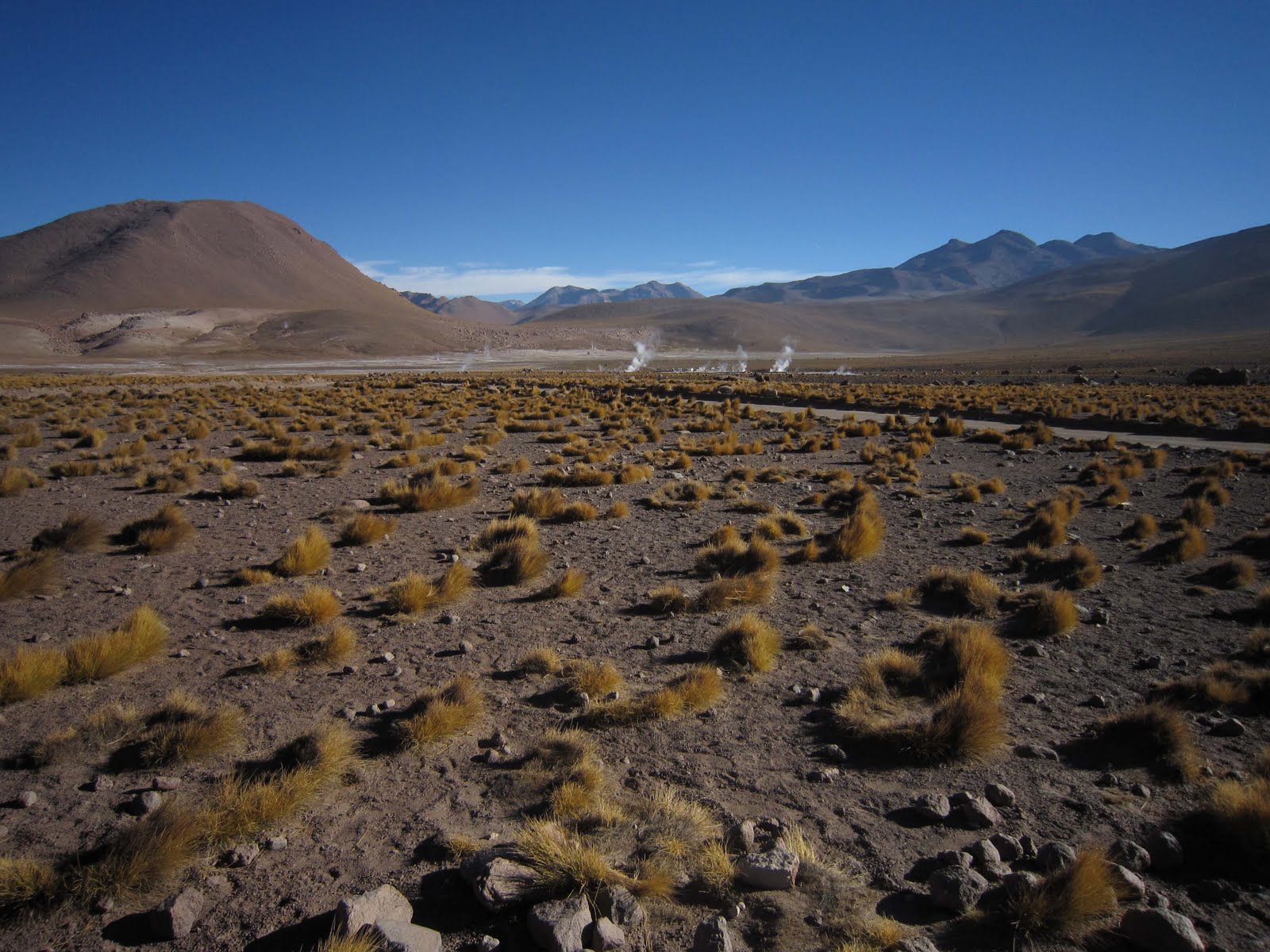
0430, joining a convoy of fast moving tourist buses already on their way to see sunrise at the Tatio geysers (the highest geyser field in the world), a couple of hours away…it felt a bit like the torchlight procession on Mont Blanc, but without the effort!
We travelled on a mixture of surfaces, but the journey was mainly on the heavily corrugated principal road that all buses seem to use for the journey there, speeding their 90km ascent from San Pedro at 2440m to over 4300m at El Tatio. This road passes across very wide sand and clay plains at higher elevations, so it was not uncommon for buses to make their own road across, and we were frequently 4 or 5 vehicles abreast as we speeded though the fog and dust of pre-dawn. Surreal.

We arrived at the entrance station at 0615, shaken but not stirred, and passed through the madding crowd to reach the geyser basin under the brooding cone of Volcan Tatio, 5215m.
In the emerging light, we observed a variety of geyser types (allegedly 64 of them), some erupting at regular intervals, others randomly spewing, whilst the rest were content to steadily steam away. There were many people here today, although sometimes it can be deserted, so pictures swiftly taken and a quick breakfast before heading away from the crowds into the head of the basin to watch vicunas and attempt to spot a long tailed rabbit called a vizcacha.


 |
| El Tatio Geysers |
As we waited at the exit gate we happened across a group of young Chileans whose car had left the road about a mile away, the consequence of a moment’s lapse of concentration by the driver. Bruised and a bit battered, we offered them a lift back down to San Pedro, a gesture gratefully accepted.
We returned by a different route, avoiding the majority of tour buses that roared their way back to San Pedro. Our route was a dramatic one, with huge vistas over the high altitude desert in the immediate vicinity of the volcanoes, which stretched as far as the eye could see, one with summit fumeroles spewing gases backlit by the rising sun. Multi coloured layers of sand, ryholitic rocks and basalt lava flows, with the welcome addition of small herds of vicuna with young, one elusive vizcacha, and one distant sighting of the rare rhea, an ostrich-like bird.


 |
| Volcanic scenery on the return route from the El Tatio geyser basin |
Our next destination was the thermal springs of Puritama, situated in a box canyon 34km from San Pedro, accessed in our case by a pleasant hour exploring the canyon, the lower reaches of which feature large cacti which seem to cling on to the precipitous cliff walls with virtually nothing to secure them. The whole canyon, and the valley in which the commercially run hot springs are situated, is vegetated with the ubiquitous brea bush and large stands of pampas grass straddling the fast flowing stream, full of tiny fish in the luxuriant 33.5 degrees temperature. Many locals were bathing in family groups below the commercial operation, but we did our bit for the local economy and used the latter, complete with changing rooms, platforms adjacent to the numerous pools and waterfalls. Very well done indeed, not too busy, and a nice spot to chill (well, actually to warm) in the midday sun.

 |
| Puritama thermal springs, Atacama |
I avoided the temptation to jump on another five hour tour to Laguna Verde, just over the border in Bolivia: too much of a good thing for one day, and with a sky back to its normal crystal blue, it was very hot indeed by now.
A quick lunch at La Estaka, with brusque but brisk service the order of the day, then a well-earned afternoon nap!
Day 6
What a day! The best yet. An illegal soiree into Bolivia, a snap decision to go off road to visit the very remote Salar de Tara, sandwiched between Bolivia and Argentina in a small niche of Chile, and close ups of vicuna and James Flamingo.
 |
| Volcan Licancabur, Atacama |
A long slog up hill, passing the left turn to Bolivia and then a surprise! I’ve always wanted to see Laguna Verde in Bolivia, and there it was, some 15km to the north. I wanted a closer view, so we headed off the road across the desert, into Bolivian territory (naughty, naughty) and were rewarded with fabulous views of Laguna Verde and the ‘white lake’ to its right. During the day, when the wind picks up, green minerals in the left hand side of the lake migrate across much of the lake, giving the reason for the name.


 |
| Laguna Verde, Bolivia |
 |
| High altitude desert, Atacama |

 |
| Vicuna |
Further on, some 40km from the Argentinean border, we passed the Salar Pusja (an important breeding site for the James flamingo), before turning off to visit the ‘Monks of Pacana’, large pointed cliffs and naturally formed rock sculptures resembling a procession of monks. Like their namesakes on Easter Island, they are also known as the ‘Moais of the Desert’.
 |
| Sala Pusja |

 |
| Monks of Pacana, Atacama |

 |
| A nice greeting on the way into Sala de Tara! |
We virtually had this enormous space to ourselves, except for Andean and a couple of James flamingos that were feeding voraciously on our side of the lake. Lunch here, after a few hundred photos (!), then we took a rocky ravine out of the pan, again with marvellous rock architecture.


 |
| Views from the remote Sala de Tara |

The final stage of the journey was uneventful, another huge descent, about 2000m in one go, to San Pedro, and one again safely ensconced in the hotel for my final night in the region.
Day 7
An early start to Calama to fly to Buenos Aires via Santiago. On the drive down from San Pedro, the clear night sky revealed masses of stars, before we spotted the distant lights of Calamar and the big copper mines nearby, the latter visible about 50km away. Once again, LAN made the process effortless at the airport.
Summary
It’s a long way to Chile from the UK, and not cheap by South American standards, but it’s certainly worth a visit. On this trip I only covered a tiny area of Norte Grande, the northernmost part of Chile, but found it truly spectacular in terms of scenery and the infrastructure and friendliness of local people are commendable. Even the loos in national park sites and small restaurants are kept spotlessly clean.
Do come and discover Chile for yourself, but try to do more than visit the normal tourist honeypots. Although sights like the Valley of the Moon and the Tatio geysers are splendid, they attract hordes of visitors and they tend to be concentrated in very small areas. Get off the beaten track, and bribe your guide to take you to the Salar de Tara!