This trip had originally been intended as a long journey through Tibet, trekking back into Nepal via the remote Limi Valley. However, at the last minute, the Chinese authorities changed the conditions for entry into Tibet, so a hasty redesign of our plans took place, with half our team going to Everest Base Camp and Bhutan, whilst three of us took off to explore the hidden kingdom of Mustang. Here's our story...
 |
| John, Bob, Cadi, David, Colin, Richard & Ralph |
 |
| Some sightseeing at Swayambunath, the 'Monkey Temple', Kathmandu before the start of trekking |
There is a 15 minute video of our trek on YouTube at http://youtu.be/_CDKEeAynT8
Friday
18 May
The
Everest team set off for the airport at 0530 to catch the first flight up to
Lukla. Happily, once we arrived at the airport at about 0730 they were nowhere
to be seen, so they had managed to get up to the trail start on this
notoriously weather prone route.
 |
| Arrival in Pokhara |
Our
flight, on Buddha Air, to Pokhara, took 30 minutes and once above the haze
build up in the terraced valleys below, we had a good view of Manaslu,
something over 8000m, gazing down on our plane as we powered westwards.
It
was hot in Pokhara, but not too humid, and we were quickly loaded on to a
minibus for the 90 minutes drive through Pokhara and our trailhead at the small
hamlet of Nayapul. The roads, again, were empty of normal traffic due to
another strike, but that was good news for us as we sped out of town,
negotiating remnants of yesterday's road blocks before reaching good roads
through the open country, with fields of maze flourishing and paddy fields
being ploughed by oxen in readiness for the planting of rice ahead of the monsoon.
 |
| Start point for the Jomsom Trail at Nayapul |
We
gained height through the village of Naudanda and were rewarded with a view of
Annupurna South and Annapurna 1, the summit snows lording it over the extensive
foothills.
From
Nayapul at 1070m we slowly worked our way up the valley of the Modi Khola, the
main river draining from the Annapurna Sanctuary. Plenty of guest houses and
spots to buy food and drink and we took an early lunch in Bhiretanti, a simple
meal of fried noodles, which fuelled us for the trek along the wide path
northwards, now in fact a rough road upon which jeep taxis ply their trade.
Huge stands of bamboo, banana trees, maize fields reflected the heat in the
next valley, the Burungdhi Khola, with the humidity slowly increasing as the
day progressed which made walking a somewhat sweaty affair.
By about 1600,
after numerous but easy ascents and descents, we arrived at our guesthouse for
the night, in the small hamlet of Tikhedhungga at 1520m. The Chandra
Guesthouse, situated high on the richly vegetated valley side, sheltered us just
in time from a heavy shower. An atmospheric spot, with the thunder rattling
around in the surrounding hills.
Shower,
beer, blog. Probably the pattern for the next few days!
Saturday
19 May
A
longer day beckons today, starting with a 500-600m climb up relatively steep
steps (the Lonely Planet authors obviously employed someone to count them...a
mere 3300 steps) to reach the forests above Ulleri (2020m). Great views back
down the valley of Bhurungdi Khola, and fine views of Annapurna South 7219 m
and its close neighbour Hiun Chuli 6434m, both snow capped peaks spearing into
the bright blue early morning sky.
We
had left Tikhedungga at 0645 to get the early morning visibility, and later in
the walk, up above the hamlet of Ban Thanti (2210m), we were able to get a view
of the twin peaks of Machhuapuchhre (otherwise known as Fish Tail) 6997m, which
is still unclimbed. A wonderful spectacle above the deeply forested slopes of
the intervening valleys.
 |
| Machhuapuchhre 6997m |
A
good path, rocky in places, but very straightforward trekking today, with
steady height gain without too much effort after the initial pull to Ulleri.
The trail passes through extensive rhododendron forest after Ban Thanti, a very
pleasant walk except for pesky flies in the rising heat of the day. The rhododendron
trees are huge, but we had missed the flowering season by about a month. A nice
lunch at Nangge Thanti (2210m) followed, and that left us with a stroll of just
under two hours to climb the final 400m to Ghorepani (2860m). As with the
previous day, the cloud quickly built up in the mid afternoon, and we were
accompanied by thunder for an hour or so, and about 20 minutes after we had
settled in to our rooms the rain started again. Good timing!

This
was a typical trek day on very good paths, one to ease us into the longer days
ahead. The guesthouse was very comfortable, even with an en suite shower and
toilet, very luxurious compared to my last trek in Nepal ten years ago,
although the facilities are still quite basic.
The
storm cleared quite quickly and our reward was a fine rainbow below us in the
valley underneath Annapurna South. Early to bed for a very early start
tomorrow...
Sunday
20 May
A
knock on the door at 0430 confirmed that clear skies were the order of the day,
and that presaged a 400m climb up Poon Hill 3210m, starting 15 minutes later.
This is a classic tourist trail, the prize a superb vista that takes in the
Annapurna range to the east and the Dhaulagiri ranges to the west, both
resplendent as the sun rose into a clear blue sky. The guidebook time is about
one hour to the summit, and I'm happy to report that the three souls in our
little group all beat that.
Of
course, we didn't have the summit to ourselves, but the view was truly
magnificent, with Dhaulagiri 8167m getting the first of the sun's rays, and
then the sun rising behind Machhuapuchhre, sun beams projecting laser-like into
the sky above it as the long sunrise unfolded in front of us.
 |
| Dhaulagiri |
 |
| Annapurna South & Machhuapuchhre |
 |
| The lads on Poon Hill 3210m |
There were many
fine peaks in view: Dhaulagiri and Dhaulagiri II, the sharp point of Tukuche 6920
m to the northwest, then the deep defile of the Kali Gandaki valley (said to be
the deepest valley it the world, with summit heights bordering it rising to
above 8000m and the river bed at about 2000m). Further to the east we could
glimpse Nilgiri South 6839m, Annapurna I peeping behind Annapurna South, and,
of course, Machhuapuchhre. Absolutely splendid. Half an hour on top, umpteen
photographs taken, and then a sustained descent back to our guesthouse, the
well-positioned 'Nice Viewpoint Lodge' (great views to Dhaulagiri) for a great
breakfast of pancakes and egg.
We
were to start our long descent at about 0740, and it was already hot in the
brilliant sunshine. We headed north, bound for Tatopani some 7-8 hours away,
most of the route a sustained descent of some 1670m, a big drop by anyone's
standards. Add this to the descent from Poon Hill earlier, that made for a
total drop of 2020m for the day...bloody hard work on the knees!
 |
| Dhaulagiri |
 |
| The Annapurna's from the west |
 |
| Large outcrops of mica on the long descent to Tatopani |
 |
| Down..., |
 |
| ...down..., |
 |
| ... and more down! |
The
path was generally very good, some steep sections down through rhododendron and
magnolia forest, although many with steps constructed from local marble (this
would be a nightmare in the wet), some sections following a roughly hewn new
dirt road, and some interesting suspension bridge crossings. Cuckoos kept us
entertained as we passed by. The route passes through some interesting geology,
large outcrops of mica providing a silvery backdrop to one long section of our
walk.
This
is a less commercialised section of the Jomsom Trail, and we passed through
terraced farmland, many small farmsteads with water buffalo and goats grazing,
women threshing cereal and drying vegetables, men sawing timber and disheveled
kids getting up to all sorts of mischief, one nearly braining me with a
catapulted stone originally intended for a bird...at least that's the story!
Our
companions on the trail for most of the day were three village dogs from
Ghorepani. They stuck close to us all day, very friendly, and occasionally
sheltered within us when approached by other village dogs and water buffalo defending
their calf, although only one pitched up in Tatopani, the other two having
found something else better to to do! Rather entertainingly, the last dog
baulked at crossing the long suspension bridge over the Kali Gandaki, made its
way down to a vehicular bridge lower down the valley, and miraculously caught
up with us.
As
the day progressed the unrelenting descent continued and we skipped lunch
because most hostelries lacked any fresh food ingredients, this being the low
season. But the compensation was that we had the trail to ourselves...hardly
any other trekkers seen all day. The only downside was that the heat continued
to rise, quite probably 30 degrees plus, and we were very glad to reach our
destination, at about 1430, the nicely situated and welcoming Old Kamala
lodging, again with 'en suite' and a fine curry as a late lunch washed down
with a very palatable Nepali beer, Gorkha. Our dog was rewarded too...what
loyalty!
 |
| Tatopani |
 |
| Spot the peak... |
 |
| Tatopani |
The
washing done (out to dry on power cables that festoon the balcony outside), the
roar of the Kali Gandaki next to us, a good night's sleep beckons...
Note:
Tatopani means 'hot water' in Nepali, and this relates to some hot springs
below the village.
Monday
21 May
A
good night's rest, quite warm in the room and peaceful. Up fairly early again,
and on the trail at about 0645. Good views to the fine peak of Nilgiri South
6940m ahead of us. We passed out through Tatopani at 1190m, a pleasant enough
little village with friendly shopkeepers, and started up the new roughly hewn
road which has only just been constructed.
This
area is very quiet at present, with the strikes (bandh) still on, and fewer and
fewer trekkers on the route now. We saw a few sadhus on the trail today, holy
men of the Hindu faith, making their way south from the pilgrimage site in
Muktinath, a spot we'll visit later on the trek out of Upper Mustang.
We
eventually crossed the Kali Gandhaki river, fast flowing and full of glacial
debris, and headed up one of those fabulous undulating paths which take you
high up above the river, not exposed, but with some great views all around.
There was a lot of wild cannabis growing all around us, and quite a few water
buffalo grazing along the way as we passed through numerous farmsteads.
 |
| Wild cannabis in profusion! |
 |
| Our companion from Ghorepani to Ghasa |
The
path had to find its way around numerous landslides but eventually we crossed
over a very high suspension bridge to make the final ascent up to the village
of Ghasa 2010m. It was here that we finally lost our doggy companion. He had
previously showed great courage around other, somewhat territorial, village
dogs, but was clearly fearful of kids with stones, water buffalo,
and...crossing steel suspension bridges. He had found his way around some of
the others by using an alternative road crossing some way away from the
pedestrian bridge and then, miraculously, catching up with us, but this was, to
excuse the pun, a bridge too far.
 |
| A bridge too far for our doggy companion! |
 |
| Primitive faming in Ghasa |
As
we approached the lunch spot, the rather grubby Kali Gandaki Guesthouse, the
temperature was very high with the sun beating down on our heads, so it was a
relief to sit down in the shade of the restaurant, reached by about 1345.
But
that turned out to be the end of the sun. Whilst we scoffed down egg curry, the
clouds that had been building up all morning turned themselves into the
inevitable thunderstorm and we sat it out for a while, entertained by a hen and
a brood of chicks also taking shelter in the restaurant area.
In
the meantime, our guide, the erstwhile Kaji, had found better accommodation 20
minutes up the hill in Upper Ghasa, so we donned waterproofs and worked our way
up the hill, through another ACAP check point (Annapurna Conservation
authority) and through a kani, an arch over the trail, with prayer wheels on
the interior walls, and this one with a tiny monastery above the arch, sadly
locked up. We're now in Lower Mustang, and there's a bigger Tibetan and
Buddhist influence here, as evidenced by some of the local architecture.
 |
| Upper Ghasa |
Our
guest house, The Golden Inn, was an unplanned stop as we had been going to
press on for another two hours to Lete at 2480m, but Kaji made a good call on
the weather, as the thunder and rain persisted well into late afternoon. This
guest house is fairly basic, no power as I write, but each bedroom has an 'en
suite' wet room and the water was just warm enough for a welcome shower. And
the temperature has now dropped to a much more comfortable level.
Happy
days...
Tuesday
22 May
A
windy night, but the rain stopped early the previous evening. A restless night,
with very conscious dreaming, something that usually happens when I start to
get into higher altitudes.
Walked
down through the village to get a snap of the little monastery at the entrance
to the village, then a quick breakfast and off again at about 0630. We started
up the rough road again, and within a few turns we were gobsmacked by the view
of Dhaulagiri and Tukuche 6920m bathed in the early morning light right in
front of us. Awesome.
 |
| Dhaulagiri 8167m |
We
are now high above the Kali Gandaki, as we ventured further along, views to the
east were dominated by close up views to Nilgiri South and the ridge emanating
from Annapurna South including the sharp promontory of Fang 7647m.
A
beautiful walk, some stunning suspension bridge crossings, and fine views all
the way. We're in a more alpine environment now, with pines and fields of
potato and barley more in evidence. There are still relatively large
settlements up here above 2000m, including Lete and Kalopani, which has a
hospital, high school and technical school for vocational training. We stopped
after a couple of hours at the nicely situated Kalopani Guest House ('Annapurna
Coffee Shop') sitting in pleasant flower gardens with massive views all around.
 |
| Kali Gandaki Nadi |
Onwards,
following the Kali Gandaki to Kokhethanti where the river valley widens
considerably to form the Kali Gandaki Nadi, a very wide flood plain. Later on
we were to cross a section of this on tiny wooden bridges requiring a little
balance or else wet feet and bum would have followed!
En
route we saw an eagle being hounded by a couple of crows protecting their nest,
and large bee nests in soft rock walls bordering the track. Big views down on
to the very wide gravel flood plain of the Kali Gandaki Nadi with the Nilgiri
range towering above the valley to the east, the three peaks of Nilgiri South,
Central and North glistening in the sun, but Dhaulagiri behind us, now shrouded
in cloud.
Lunch
was taken in the Larjung Guesthouse at 2564m, a break very welcome as it had
got very hot once again. Clear skies still at lunchtime with a breeze blowing
down the wide expanse of valley.
Larjung
has a Tibetan feel, and there is a Nyingma monastery standing above the village
called La Thau with the shrine of Gauchang, a local Thakali family dynasty,
nearby. We then dropped down on to the vast gravel plain of the Kali Gandaki
Nadi, fairly dry at this time of the year, pre-monsoon. It was a fair tramp
across these barren expanses with a strong gusty wind on our back and spots of
rain falling from the rapid build up of cloud that had occurred while we were
having lunch. But in 90 minutes we reached Tukuche 2590m, and our lodgings at
the Laxmi Lodge. We could be in Tibet here, small gompas throughout the town
and the distinctive flat roof architecture. The guesthouse was also Tibetan in
character with the usual inner balconied courtyard with rooms off, and brightly
coloured paintwork throughout. Very pleasant indeed.
 |
| Tukuche |
Note:
Tukuche was once a prominent Thakali (the generic name for people in the Kali
Gandhaki region) village, enriched by its position as a meeting place for salt
merchants from Tibet and grain suppliers from the south. 'Tuk' means grain, and
'che' means flat place. This trade has now withered but the remnants of its
rich trading position can still be seen in some of the fine traditional
properties in the town.
Wednesday
23 May
A
good sleep last night, as Tukuche is a very quiet village. Awoke early as
usual, and walked around the back streets of the village and had an ageing nun
open up a small gompa for me. Poor lady, terrible lungs, but gracious enough to
let me spend time studying the iconography.
 |
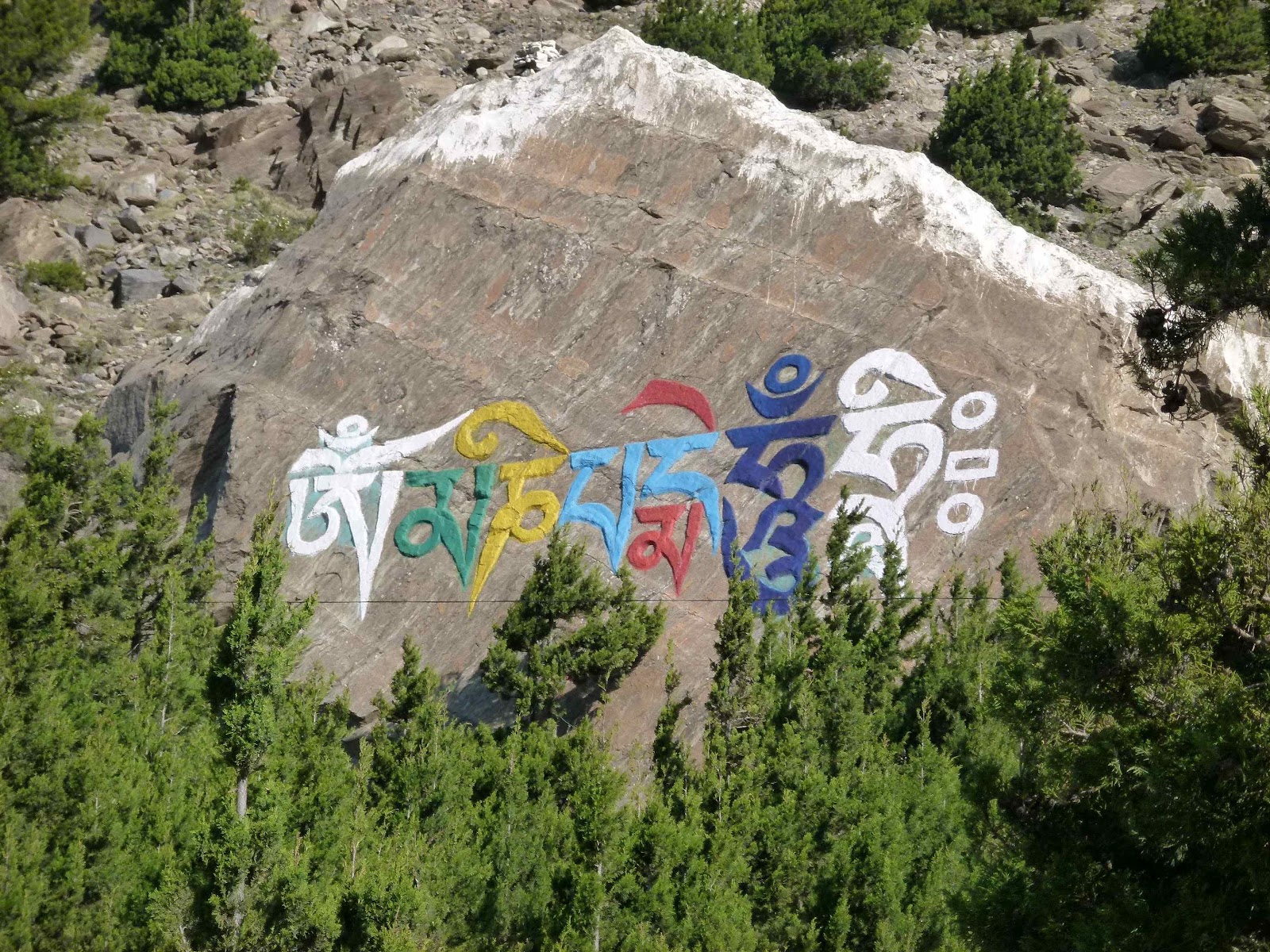
| Tukuche |
 |
| Om Mani Padme Hum |
 |
Tukuche in the early morning sun
Off
at 0700, following the rough road northwards and the Kali Gandaki to our right,
grey with sediment from the glaciers above. The summit of Dhaulagiri was
visible in the bright morning light...very impressive. After 90 minutes rising
up through apple orchards and barley fields, we reached the scruffy lower
reaches of Marpha 2670m ('Apple Capital of Nepal'), and then we veered left
into Old Marpha to visit the large Buddhist Gompa, another Nyimgma temple
reached via steep steps with prayer wheels running up the middle. The old town
is hugely atmospheric, and it's like going back into medieval times, narrow
alleyways, firewood on all the roofs, kitchens billowing smoke from wood
burners.
|
The
gompa was very quiet, and is situated just below a meditation centre, and the
central figure in the main temple hall was a red Buddha figure, which with my
limited knowledge I deduced to be Amitābha (but I'm
probably wrong!). Walls adorned with the usual deities like Mahakala.
 |
| Old Marpha |
 |
| Entering the gompa in Marpha |
 |
| Yab yum |
As
we departed northwards from Marpha the terrain changes very significantly. A
dry, arid landscape stretched ahead of us, and the geology is now very
distinctive, with wind eroded loess and sandstones.
From
the start of our walk today we've seen planes flying into and out of Jomsom
2720m (pronounced Zomsom), our objective for the day, but they have to fly in
very early as the winds created in the divide between the Dhaulagiri and
Annapurna ranges become very strong later in the day, and nothing can fly in
and out of this airstrip. The wind was a feature of the latter half of our
walk, fortunately on our backs from the south, but producing a very dry and
dusty atmosphere requiring us to don our Buff face scarves...this will be life
for the next 10 -12 days!
 |
| Looking back to Marpha |
 |
| Jomsom ahead |
 |
| Entering Jomsom |
 |
| Face scarves to protect against the wind and dust, Jomsom |
Entering
Jomsom, the biggest town we've seen for days, you can see the airstrip and then
the wide street adorned with equipment shops, a motorbike dealer, and numerous
'German' bakeries...some apple strüdel later
methinks...
An
early finish today, so lunch, some rest and some washing, then out into the
town to try the local Magic Bean bakery, which supplied excellent coffee and,
yes, you've guessed it hot apple strüdel...yum.
We're
staying in the Hotel Himalayan Inn, 150m to the tiny airport, whose entrance is
accessed off the main street in Jomsom. It has good, hot showers and wifi...so
a lot of blog uploads and catching up on email filled the afternoon. Somewhat
disturbingly, there's the wreckage of an aircraft that crashed a couple of
weeks prior to our visit (killing fifteen people) high up on the hill above the
town. We had a fine view of it from the dining room...something to think about
when we leave Jomsom by plane in a couple of weeks time!
 |
| Wreckage above the town of Jomsom |
 |
| Our guesthouse in Jomsom. Nilgiri in the beckground |
Thursday
24 May
Entertained
by the daily air schedule arriving into Jomsom directly behind the hotel, it
was interesting to see a 15 minute turnaround from landing to take off again.
Great views to Nilgiri from the bedroom window too.
 |
| Views southwards to Jomsom |
Off
a little later today as our guide Kaji had to sort out provisions, four ponies
for our camping gear, and one to ride in case of injury or fatigue, for the
next stage of our trek into Upper Mustang. A beautiful morning, and easy
walking through the northern part of Jomsom, past the Nepalese Army Mountain
Warfare Regimental HQ and out on to the eastern side of the Kali Gandhaki
valley, a vast wasteland of gravel and sand, which will be covered by flood
water after the monsoon rains in July and August feed the glaciers further
north. Apparently the Kali Gandhaki becomes the Thak Khola at this point.
Many
miles later brought us to a teahouse at Ekle Bhatti, and we had enjoyed
impressive views southwards to Dhaulagiri, Nilgiri and Tilicho so far. But the
eye was now drawn to the huge rockscapes to our west, the entry point into the
remote region of Dolpo, and the canyon like landscape to the north...our
objective for the next 12 days, Upper Mustang.
 |
| Leaving Jomson, Nilgiri towering above us |
 |
| Approaching Kagbeni |
Thankfully,
the wind came up from the south at about 1030, easing us along the way and
before midday our camping point for the night came into view, Kagbeni at around
2800-2900m. Situated on the banks of the Kali Gandhaki, this is a little oasis
of poplar trees and barley fields on the southern reaches, and our camping spot
was behind the Nilgiri View Hotel in a small walled courtyard, excellent
protection from the intensive afternoon winds.
 |
| Entrepreneurship in Kagbeni! |
After
a quick lunch prepared by our new camp cook, we took a walk to the town's ochre
coloured gompa, Kag Chode Thupten Samphel Ling, a small monastery of the Sakya
sect, with a monk population of about 35. They are currently inviting sponsorships
to support young monks training here. This was a very old structure with small
dukhang, featuring a Maitreya Buddha surrounded by images of Sakya lamas of
note. There was an excellent Wheel of Life at the entrance.
 |
| Kag Chode Thupten Samphel Ling |
Climbing
up steep stairs to the roof gave superb views up and down the valley, to
Dhaulagiri and the mountains to the east, which the Thorung Pass of Annapurna
Circuit fame intersects. There was also a surprise in that the old town was
revealed from this position, very old compacted mud structures contrasting the
numerous, very scruffy, building sites
in the newer part of the town.
 |
| Kagbeni |
We
popped into the checkpoint where we have to present ourselves tomorrow morning
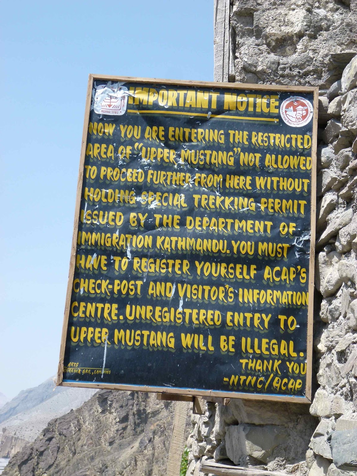
in order to be able to venture further north. The permit to trek into Upper
Mustang is relatively expensive at $500, but this limits numbers in a region
which is very fragile environmentally and has limited facilities for tourists
and trekkers. Looking at the stats presented on the wall, they have had an
average of about 750 visitors per annum in Upper Mustang since access was
opened up in 1992. Visitor numbers are around 1000-1100 p.a. these days, so a
quick calculation suggests that the region has probably had no more than 20,000
visitors over the last twenty years...we are privileged indeed! Only 5% of
visitors passing through Jomsom venture there, 49% go to Muktinath (mainly
Indian Hindu pilgrims), 41% are trekking the Annapurna Circuit and the balance
walking the Jomsom trail back towards Pokhara.
 |
| Northwards into Mustang |
We
ventured into the old town, absolutely fascinating again, and really like
stepping back into the distant past, families living in hidden courtyards off
narrow alleyways to protect them from the relentless wind that blows up from
the south from mid morning every day, with their animals, goats, ponies and
cows living in very close proximity. Fascinating, but you can feel the poverty
here, even compared to Jomsom, three hours walk to the south.
Back
to the camp, tents set up now, and relieved to get out of the wind at last. A
sign of conditions ahead...
Friday
25 May
Not
a bad night in our sheltered camp spot. We were all awake after the 0430 bells
at the nearby gompa, closely followed by the horns used by the monks in their
early morning prayers, and we were quickly ready for breakfast and our entry
into the ancient Kingdom of Mustang. By 0730 we were through the control point,
and immediately climbing the east side of the Kali Gandhaki valley to reach a
superb contouring route through increasingly incredible rock scenery. Most of
the rock seems to be alluvial, some fine grey sandstone interspersed with rough
conglomerate, and scree fans everywhere. Fine views at the start, south to
Nilgiri and eventually we could see the Dhaulagiri Himal range from afar, but
our perspective was dominated by the awesome and constantly changing canyon
scenery that unfurled ahead of us. A few steepish sections but we were quickly
above 3000m and enjoying fine but somewhat hazy conditions.
 |
| Kagbeni from the north |
 |
| Kali Gandaki, our companion northwards into Upper Mustang |
 |
| Goodbye to the Himalaya, receding into the distance |
 |
| The rocky road ahead... |
 |
| John, Richard and Colin heading into Upper Mustang |
Crossing
small scree fans every few steps, you are reminded of the power of nature here,
the heavy snows of winter and the wind blasting through each day has created an
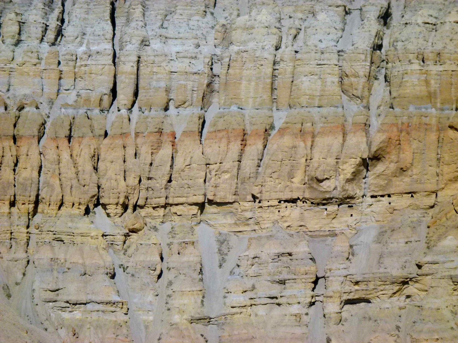
incredible landscape of fluted cliffs and sandstone bluffs. Red, white and
black chortens, unique to Mustang, greeted us on the approach to the small
settlement of Tangbe. Here we had a long stop and early lunch.
Tangbe,
a Gurung village at 3060m, is set on the side of the main valley but irrigated
by side valleys, enabling some barley, buckwheat and apple crops. Like most
towns in these parts, everybody and everything lives in enclosed courtyards to
keep out of the strong, gusty and dusty afternoon wind that blows up from the
south each day. The landscapes so far have been very Tibetan in character, high
brown rolling hills up to about 4000-5000m, with sporadic snow capped peaks
above 6000m above them, but the dominant feature has been the valley and the
wind eroded features along the way.
Trees
are now few and far between and the lack of grazing for animals means that they
are usually corralled in walled enclosures within the towns with fodder brought
daily to them.
Some
'traffic' early morning, as some of our route follows a jeep track created 4
years ago, although this terminates at
our destination for the day, Chele at 3100m. A few jeeps, the odd tractor, but
the majority were mule and pony trains accompanying the four or five trekker
groups who are on the same mission as us.
After
lunch, the rock scenery went ballistic, huge sandstone cliffs, isolated wind
blasted nodules (I think the Americans call them 'hoodoos'), and we could see
wind action real time, blowing stones down the heavily grooved valley sides.
Every turn brought new features and astonishing views. I likened it to being in
the Grand Canyon, with intermittent Bryce Canyon features.
 |
| Chhusing |
We
reached Chhusing, 3050m, easily, and on the approach were shown the meditation
cave complex said to have been used by Milarepa, one of the great promulgators
of Buddhism in Tibet.
On
the western side of the canyon are many caves, populated by early settlers in
the region, and these continue northwards to Chele. Nearer Chele, some caves
are said to be burial sites.
After
Chhusing, we dropped into the valley bottom, crossing river gravels before
crossing the river on a steel bridge next to a rock tunnel through which the
river flows, and then a short but steep climb up loose scree brought us to our
camp site in the village of Chele, another walled compound to keep out the
wind, but with great canyon views northwards.
We
managed to get a Tuborg in a little guesthouse whilst the team put up the
tents...a good day for all!
 |
| Rock caves at Chhusing |
 |
| Approaching Chele |
 |
| Chele |
 |
| Camp at Chele |
A
quick historical perspective on Mustang - the region is more properly known as
Lo, thought to have been visited by Milarepa (1040-1123) and once part of
Ngari, now a province of western Tibet. Ame Pal is said to have been the
founder of the kingdom in 1380, and the present king (raja) of Mustang can
trace his lineage back 25 generations to him. Mustang retained its status as a
separate principality until 1951, but was then absorbed into Nepal, with the
raja given the position of honorary colonel in the Nepalese Army. A boundary
treaty between China and Nepal in 1963 ceded parts of northern Mustang to China
in return for Nepalese territorial gains on both sides of the region. Today,
there is an estimated population of 27,000, many of whom maintain strong
trading links with the south and increasingly with China over the nearby
Tibetan border.
Saturday
26 May
Technically,
Upper Mustang really starts from the town of Samar, our first objective today,
necessitating a continuous climb of about three hours. But what a day! The
toughest of the trek by far, we trekked for about 8 hours plus stops. We
started the initial ascent at 0650, rising steeply out of Chele village and
soon climbing a superb trail up the north side of a canyon overlooking the
village of Ghyakar. A puja was underway in Ghyakar, possibly marking the start
of summer, with a procession led by a drummer circumnavigating the village
which was soon far below us on the other side of a spectacularly deep canyon.
Ultimately, an easy traverse brought us to Chele La at 3630m, and massive views
lie ahead of us, almost dizzying to look at. Bloody fantastic.
 |
| Fine walking out from Chele |
 |
| Ghyakar |
 |
| Chele La 3630m |
From
the pass we descended to the village of Samar 3620m, surrounded by poplar trees,
and with more cattle than people, a notable dwarf breed grazing just outside
the delectable Hotel Himali, where we stopped for lemon tea. Our genial host
also posed for photos and offered us a sample of butter tea...not my taste, but
clearly enjoyed by our guide, who then tucked in to a traditional bowl of
tsampa. He clearly knew what was ahead...
 |
| Samar |
 |
| The King & Queen of Mustang |
 |
| Leaving Samar |
Clearing
this beautifully situated spot, with massive views of the Annapurna range to
the south, we passed through the obligatory mani gate to be confronted by our
next task. We were to take an alternative route to the main path in order to
visit a particularly sacred spot, the Chyungsi Rhangchung cave monastery,
hidden away in a deep canyon at 3400m.
A
sharp descent to cross one ravine followed, then we veered off the main track,
crossed an even deeper ravine, losing height all the time. Crossing some open
countryside we got barked at by a Tibetan Mastiff, thankfully chained up, then
started up the long slog to a minor pass at about 3780m. What a view when we got
there! Massive canyon scenery to our north and east and the vastness of the
snow capped Himalaya to the south.
 |
| Another pass or two ahead! |
 |
| Looking back to Samar |
A
high level narrow traverse flanked by juniper bushes brought us to some more
prayer flags, and then the enormity of what this alternative route meant was
laid before us. A very steep descent, leading to a narrow high level traverse
on one side of a steep canyon containing the Syangboche Khola, then a further
steep ascent to the village of Syangboche a long way ahead, but at about the
same elevation as we were at the pass. Gulp. Still, it had to be done, and the
descent was rapid, the traverse safe throughout and we eventually arrived at a
turn in the canyon. Here we found we had to make a steep climb, ultimately up
rock steps, to reach this most sacred of caves.
 |
| Descent to the Chyungsi Rhangchung cave monastery |
 |
| Climbing out of the canyon to reach the cave monastery |
Said
to have been a meditation site for the famed Guru Rinpoche (Padmasambhava) in
the 8th century, it is now home to a lama (away ill in Kathmandu) and a dumb
guardian. The cave is festooned with silk katas, chortens and all the usual paraphernalia
of Tibetan Buddhist iconography and ritual items. We lit butter lamps with our
guides as a mark of respect, took some photographs of the inner cave, then beat
a retreat back down the steep steps in order to commence the final grinding
climb out of the canyon. This took about 90 minutes and we had a late lunch at
a guesthouse in Syangboche at about 3800m.
 |
| Chyungsi Rhangchung cave monastery |
 |
| More descent! |
 |
| The long grind out of the canyon to reach Syangboche La |
The
final ascent to Syangboche La at 3850m was quickly despatched and another view
of the high altitude desert that typifies Upper Mustang unfolded before us in
the mid afternoon haze.
We
now had a one hour descent to our camp for the night, in the village of Ghiling
(Geling), at 3570m. By now the usual strong wind from the south had blown up,
blasting dust on our backs and flying grit stinging the bare flesh on my arms.
This is a barren, inhospitable environment, but wondrous in its scale and
rawness.
 |
| Geling 3570m |
 |
| Camp at Geling |
The
camp hadn't been set up when we arrived as it took quite a few chaps to hold
down tents in the wind, so, in time honoured fashion we repaired to the
adjacent teahouse for a swift beer or two...some things never change! Quite a
day...
Sunday
27 May
A
disturbed night. Just as I was dropping off the locals decided to use up the
last of the explosive used in recent Tsechu celebrations. Kaboom! Heart went
racing, wide awake again. Eventually slipped into sleep, then the dogs started.
Not quite symphonic in nature, just random bursts of extremely irritating
barks. All night.
Anyway
it was a pleasant enough start to the new day, and after breakfast we visited
the nearby Sakya gompa, high above the houses with highly decorated chortens
guarding the entrance. We were welcomed by a lone monk who had been beating a
large drum as part of his early morning ritual. He showed us a severed hand,
400 years old, said to have been cut off by a man himself having made a small
error on a thangka painting.
 |
| Goats among the mani stones |
 |
| Chorten at Geling |
 |
| Monk showing us a 400 year old severed hand... |
 |
| Wall murals in the Sakya gompa in Geling |
 |
| Richard with ancient gun in the gompa |
 |
| Nyi La 4020m |
As
we walked away, the drumming resumed, followed by the usual horn blowing.
We
walked away from Geling, steadily gaining height on a wide barren plain, and
then a good path brought us swiftly to our first pass of the day, Nyi La,
4020m, with huge views south to the snow capped Himalaya, albeit quite hazy
this morning, and barren brown desert like hills to the north. An easy
contouring path brought us to another small pass, Ghami La 3645m, this time
with views north to the village of Ghami 3510m and its extensive barley fields.
A short steep descent brought us on to a more gradual path into the village,
home to Mustang's longest mani wall (about 300m long), and a good clean
teahouse just as we entered the village. Great lemon tea.
 |
| Leaving Ghami |
The
village is quite decrepit but full of character with various decorated stupas
and chortens. We climbed down to the river beyond, and then started up a climb
to the end of a spur, affording extensive views to the Annapurna and Mukti
Himalaya ranges, a vast swathe of 6000m plus peaks to our west, and an exciting
red sandstone canyon directly ahead of us. The path from here took us gently
down to the isolated village of Dhakmar 3820m, in time for a late lunch
prepared by our crew.
 |
| Approach to Dhakmar 3820m |
Dhakmar nestles under magnificent red sandstone cliffs,
with many caves that have been excavated, presumably for meditation or burial
purposes. We arrived just as the daily southerly started up, with clouds of dust
flying at speed as our boots kicked up the fine dust on the path. Nice spot for
an overnight though, with a cuckoo serenading from the meditation caves above
and an eagle soaring above the valley in front of the campsite, showing off in
the blustery winds with its superb aerodynamic abilities.
 |
| Dhakmar |
 |
| Camp at Dhakmar |
Monday
28 May
A
big day ahead, following a reasonable nights kip, the village dogs doing their
usual night-time serenade.
It
was quite chilly this morning despite clear skies, as we are at 3820m and in
the shade of the sandstone cliffs directly above us to the east.
 |
| Distilling alcohol to produce local 'hooch', Dhakmar |
Off
at 0700 again, a multiple pass day but with the objective of reaching our
ultimate goal, the capital of Mustang, Lo Manthang. Passing through the upper
reaches of the village, we could see extensive barley cultivation and herds of
goats, about the sum of farming up here. Crossing a stream the first big pull
of the day was ahead of us, about 200m up a rocky gully, somewhat similar to
the rock formations of Zabriskie Point in Death Valley. Everyone made quick
progress up this and the views at the top were stupendous, the white capped
peaks of the Annapurnas once again doing their thing, and a decent view of
Annapurna I this time too.
 |
| Ascent of the passes north of Dhakmar |
 |
| Views south ... awesome! |
 |
| Happy days! |
An easy plod brought us to the next pass, Muila
Bhanjyang at 4170m, a new height record for the team, with views forward to our
first stopping point of the day, the famous Ghar Gompa, situated in a valley
above Lo Gekar at 3920m. This is a famous Nyingma monastery, established after
a visit by the Indian mystic Padmasambhava, in an effort to subdue the 'demons'
that were preventing the construction of the first monastery in Tibet, Samye.
It's a fairly small gompa, excellently situated, with six resident monks and
the usual guardian, who was most helpful.
 |
| Approaching Ghar Gompa |
 |
| Ghar Gompa |
The monks were chanting in readiness
for the forthcoming Saga Dawa festival, and many women from surrounding
villages were congregating in another part of the monastery for the same
purpose. Shown around inside, unfortunately no photos allowed this time, it was
notable that the iconography was all about Padmasambhava and assorted wrathful
deities rather than images of the Buddha. The monks were chatty in between
chanting, and we eventually repaired to another part of the monastery to light
butter lamps as a devotional to the Buddha and in respect to our hosts. A nice
visit and we were made very welcome.
Late
morning now, and a bit of work still to do, crossing a gully and then a long
slog up a featureless valley, which eventually took us to Marang La 4230m, and
a quick picnic lunch in the strong midday sunshine.
 |
| Marang La 4230m |
Ahead
of us to the west we could see the mountains of the Kekyap Danda, rising above
6000m, and the snow cap of Kyangkung Dula 6037m. To the north and east, a new
high altitude desert landscape revealed itself, multi-coluored by mineral salts
that have evaporated out of the rocks. This was a long descent, and finally Lo
Manthang came into view in the distance, set amidst a small oasis of poplar
trees and barley fields, and sheep and goats grazing the lower pastures. Once
again, amazing vistas, but tired feet took the shine off the final hours'
walking, and we were mightily glad to reach the camp site just outside the city
walls. Amazingly we have not seen one other trekker all day!
More
on Lo Manthang when the energy returns tomorrow!
 |
| Approaching Lo Manthang |
 |
| Here at last!! |
 |
| Camp in Lo Manthang |
Tuesday
29 May
An
uneventful night, thankfully with no dogs barking and just the sound of a herd
of goats in a pen next to our camp, their bells jangling gently through the
night.
A
nice morning, cooler in the early breeze, and a late start today as we were to
spend a day exploring the ancient walled town of Lo Manthang.
 |
| The city gate of Lo Manthang, capital of the ancient kingdom of Lo |
First
we visited the Monastic Museum which forms part of the Tsechen Shedrubling
Monastic School at Choede Monastery, just inside the city walls. Students, some
as young as six, were assembling for morning classes and the Principal,Chhing
Chhyope, gave generously of his time to show us around. Ancient masks for
festival dances, thangkas over a thousand years old, and many ancient ritual
artefacts. Fascinating stuff. Like other monasteries within Lo Manthang, this
facility is slowly being improved with funding from the American Himalayan
Foundation and the Swiss Schulverein Lo Manthang.
Next,
we were privileged to be shown the stupa hidden away in a small but highly
decorated room, containing the remains of the lama who helped this community in
the early days.
 |
| Tsechen Shedrubling Monastic School at Choede Monastery |
 |
| Sand mandala instruction for young monks |
On
to the main monastery on the site, the Dragkar-Thegchen Ling Gompa, first
established during the reign of the first king of Lo, King Ama Pal, by the
scholar Ngorchen Kunga Sangpo in the 13th century. It is now the premier gompa
for the region and is of the Sakya order.
We
moved on through the characterful walled city, the people of the town really
impressing us with their friendly welcome, from the throaty 'Namaste' from the
weathered old guys at the only city gate, or from random people on the street,
women hauling rocks for a new guesthouse, or the lady plying good Illy coffee
opposite the mani wall and chortens greeting visitors entering the city from
the north.
Our
next stop was the tallest gompa in the city, Jampa Gompa, built during the
reign of the second son of Ama Pal in the 14th century. Sporting large tantric
mandalas on the walls and a large Maitreya Buddha (Jampa Chempo) in meditative
posture, this monastery is undergoing a slow process of restoration. Great
views are had from the roof over the whole city, enabling you to peer down into
the many courtyard dwellings clustered around the gompas and the royal palace.
 |
| Rooftops of Lo Manthang from the Jampa Gompa |
The
final visit of the morning was to the adjacent Thupchen Gompa, built during the
reign of the third king of Lo in the 15th century. This is a hugely impressive
monastery, and we met an Italian couple who have spent the last eleven summers
helping to clean and renovate the intricate wall murals, mainly featuring
various manifestations of the Buddha. Painstaking work, using local rocks and
minerals to recreate the original colouration. We were shown a block of
cinnabar, a mercuric compound used to give a red tint. Elsewhere women were
preparing intricate pinpoint stencils. Marvellous work, again funded by the
American Himalayan Foundation. Other features of the monastery included statues
of the four Guardian Kings in the entrance vestibule and images of Chenrezig,
Manjushri, and Guru Rinpoche as a central feature. Beautiful work throughout
and really worth a look as renovations progress in the years ahead.
 |
| Street scenes in Lo Manthang |
 |
| Chorten in Lo Manthang |
 |
| The walled town of Lo Manthang |
 |
| Buddhist mantra carved into yak horn |
Some
chill time back at the camp and an early lunch preceded a walk up to the
Namgyal Gompa which sits to the north west of the city on a ridge. This is a
Gelug monastery but was closed as extensive rebuilding is underway here too.
Vast landscapes seen from this vantage point, and we could see the cloud plumes
streaming off the peaks to the south, including Gangapurna and Annapurna I.
On
our descent we passed through a really traditional Tibetan village. Following a
sandy track in the blustery afternoon wind, we gained views down the Nhichung
Khola, a northern extension of the Kali Gandhaki, with magnificent rockscapes
extending all the way to the Tibetan border, now only 15-20km to the north. So
near, but yet so far...
 |
| Bricks drying in the sun outside Lo Manthang |
 |
| Yak dung drying out...good for burning in stoves! |
 |
| Looking south to Lo Manthang, the Himalaya on the skyline |
As
we traversed the slopes we happened upon a large griffin vulture, which took
flight as we approached to reveal its huge white and black wings. We are
reminded that the people of Mustang still use sky burials for most deceased,
only the royals being cremated.
Returning
to city through the northern slope, we treated ourselves to a beer, then waited
for a tour of the King's Palace, Tashi Gedphel Gyalkhang.
Previously
we had been advised that the King, Jigme Parbal Bista, now aged 80, was unwell
and was being treated in Kathmandu. However, to our surprise and delight we
found ourselves being presented to the king himself, each of us offering a
traditional white silk kata and he then placing it back around our neck. There
followed tea, about seven of us with a small number of guides, and after a
somewhat awkward silence, a few questions were asked of him. I, of course,
volunteered Richard to ask if the Dalai Lama had visited Mustang, but of course
he hadn't because Mustang is so close to the Tibetan border and this would be
'politically unacceptable'. Silly me, I should have known!
 |
| Presented to the King of Mustang |
The
palace itself was ramshackle and accessed up steep unlit wooden staircases, but
a very atmospheric experience for all.
A
great day in this marvellous city, and with very few tourists about. A real
treat.
As
the day ended, the winds strengthened and it got noticeably cooler. A cold
night ahead...
Wednesday
30 May
 |
| Lo La 3960m |
Another
bright, dry day dawned and an 'easy' day down to the next village south on the
main trail through Mustang. We entered very arid country, and the track
followed a dirt road most of the way, which was incredibly dusty. Fortunately
no wind in the mornings here, so good progress made initially with fine views
back to the confluence of valleys containing Lo Manthang.
Walking
through low canyons we crossed the Lo La at 3960m, and the trail went steadily
downhill most of the way with the southern panorama unfolded in front of
us...the snow capped peaks of Tangki Manang, Thorung Peak 6144m, the fine
pyramidal summit of Khatungkang 6484m, Annupurna I, Tilicho Peak and our old
friend Nilgiri Himal.
For
me, this was when my energy ran out. A couple of weeks of relatively hard
trekking behind us, the body said 'enough!'
We
could see tomorrow's route from our track and noted that it would involve a
couple of hours back-tracking from our overnight camp to cross the deep canyon
of the Thulung Khola. Descending, then re-ascending the side canyon of Charang
Khloa to reach our overnight stop in Charang (Tsarang) further depleted
reserves and it was here that the decision was made to skip tomorrow's route
which had us eventually going eastwards to a spot called Yaragaon, and head
straight down the valley to Tangge, leaving us with just four trekking days to
reach the airstrip at Jomsom. My companions willingly agreed as this
potentially gives us a full rest day in Kathmandu before a tough 10 day trek
planned in the Humla region through June. Subject to...being able to cross the
next big canyon, and the river within it, and bringing two domestic flights
forward!
The
other thing playing on my mind today was our other group, having successfully
completed the Everest Base Camp trek, had been stranded in Lukla for two days
due to bad weather, so were to get a helicopter down to Kathmandu. Later in the
day, it was confirmed that they had got down safely, so that's a relief!
 |
| Rock caves south from Lo La |
 |
| Descent to Tsarang |
 |
| The largest chorten in Mustang |
 |
| An exhausted trio just north of Tsarang... |
Back
to today. We reached the large village of Tsarang and our camp for the night
behind the Kailas guesthouse. All of us were shattered so an early afternoon
kip revived us somewhat and we ventured through the village, this one somewhat
scruffier than we had seen elsewhere, and visited the Tserang Thuten Shedrup
Dhargyeling Monastery, another Sakya centre (ignore any map saying it's a Gelug
monastery) and went up to the old royal palace for views down the canyon of the
Charang Khola.
The
monastery was in a state of chaos as there was a substantial amount of
refurbishment being done in preparation for the forthcoming Saga Dawa festival
and other seasonal pujas. However we were able to view an impressive Maitreya
Buddah encased in a gilded wooden framework, and there were many fine silk
finishes throughout the monastery. Some of the Buddha images at the rear of the
main hall had also been nicely cleaned and renovated.
A
lazy afternoon followed...
 |
| Tserang Thuten Shedrup Dhargyeling Monastery |
 |
| Caves in the canyon alongside Tserang |
 |
| Tserang Thuten Shedrup Dhargyeling Monastery |
Thursday
31 May
Doggy
city...the bloody things barked all night, which was alright when the ear plugs
stayed in!
An
early start, notable for the fact that our guide was busy on his prayer beads
from the off, as we had asked him to do a route he had not done before. We
passed the gompa, and headed out across the irrigation channels which enable
all the crops growing in these parts, mainly barley here but considerably less
advanced in growth compared to that seen at lower elevations. After a hesitant
look down one or two gullies, we found the main route down to the canyon floor,
a steep but safe scree path that took us rapidly down almost 300m to the bottom
of the Charang Khola at its meeting point with the main defile of the Kali
Gandhaki Nadi.
 |
| Descent to the Kali Gandhaki Nadi |
 |
| Some exciting river crossings! |
Checking
with a young girl who, amazingly, maintained a small bhatti in a tent behind a
stone wall windbreak, we set off into the wide gravel flats of the main canyon,
jumping on our horse to cross the fast flowing river, thick with grey sediment
from the glaciers above. Relatively easy walking, losing almost another 200m
over the next couple of hours, on and off the horse, narrowly avoiding wet
boots as the horseman valiantly led the horse on a lead, himself almost waist
deep in the powerful current.
 |
| A long haul down the river gravels of the Kali Gandhaki |
After
about three hours we left the main canyon and its vast yellow sandstone walls,
and turned east into the Tangge Khola, necessitating more river crossings on
horseback. It made a change from grinding uphill across this high altitude
desert, the pattern of the last few days. Eventually, the village of Tangge
3240m came into view with the usual entrance chortens up to our left. And,
across the valley we could see the formidable task we'll have tomorrow when we
cross over a 4380m pass on our way to Tetung and then Muktinath.
Good
job we had hired the horse!
The
camp site offers lofty views back down to the canyon we had just navigated, and
our hosts tonight have the most simplest of accommodation adjacent to the
camping area. Two older women, one with a single leg, and the other a little
simple, seem to run the show, and only speak Tibetan, so there were a few
communication challenges with our Nepali guide and crew. There are some young
adults about, so, in between eating tsampa, the staple food in these parts,
chewing gum, and playing with a mobile phone, we did get some communication
going!
 |
| Basic teahouse in Tangge |
 |
| Camp at Tangge |
Later
we had a walk up into the village...quite literally the land that time forgot.
Narrow alleyways, an abandoned gompa, and an impressive series of chortens,
some with roofs built over them...not seen that before. We could see the start
of our route tomorrow, and the pass that was our first objective. Not the tIme
to think about that now...dinner and early to bed.
 |
| The wonderfully isolated village of Tangge |
 |
| Chortens in Tangge |
 |
| Om Mani Padme Hum... |
 |
| More rock caves... |
 |
| Start of our long trek tomorrow... |
 |
| Tangge |
Note:
the Lonely Planet guide to the route we're now on refers to the isolation of
the villages of Tangge and Tetang, and the lack of even basic facilities. Plus
being prepared for at least one ten hour (more than 30km) day...that'll be
tomorrow then...
Friday
1 June
Given
the length of the day ahead, we set off at 0630, dropped down to a river and
crossed it by an old wooden bridge, followed by a climb over a spur to the main
valley of the Tangge Khola. The river necessitated assistance again from our
horse and one hour after setting off we were starting the long climb to the
first of the day's passes. Starting at 3450m we made quick work of the first
400m, in just over the hour, with a cool morning breeze offsetting the sun bearing
down on us from the east. The path worked its way up through sandstone bluffs,
and looking back to Tangge, there were hazy views of the surrounding canyons.
Wild country indeed.
 |
| Looking back to Tangge |
 |
| Start of our long climb to the next pass |
 |
| Still a lot of climbing to do... |
After
two and a quarter hours, we reached the first pass at about 4250m, and ahead of
us, in the far distance, was the next one! One and a quarter hours later we
reached that one, at about the same altitude, only to notice that the path
continued to rise. Ho hum.
 |
| Yeh, another pass! |
Following
a high level path around interlocking spurs, we eventually realised the most
magnificent of views to the south. Despite the haze in the canyon lands of
Mustang, the Annapurna and Dhaulagiri ranges stood proudly above the clouds,
resplendent in bright sunshine. What a view! And we seemed nearly up there with
them, despite their being 25-30 miles away.
The
path became truly spectacular, winding its way up on to a long ridge called
Siyarko Tangk Danda, and the path maintained a height of about 4100m
throughout, with huge drops into multi coloured canyons to the south, above the
Narsing Khola, deep in the canyon below. The rock scenery was some of the best
I have ever seen.
 |
| Stupendous ridge walking along the the Siyarko Tangk Danda |
 |
| The Annapurna range to the south, just a couple of days away... |
A
quick lunch was taken about halfway along the ridge and we had our guide do a
SATS test using is portable device: my reading was oxygenation at 83% and heart
rate at 100 bpm, and Kaji's was 95% and 115 - my two companions failed to
register any results...they were either momentarily comatose or producing
results that the little machine couldn't interpret!
After
lunch we made a quick ascent around a rock pinnacle on the ridge, which brought
us on to the descent route, easy at first, dropping about 300m on an easy gradient over about two
miles, and giving us the chance to take in the views all around without
worrying about our feet.
But
that was to change in an instant. Suddenly the path veered south into the
canyon, the slope steepening considerably, and scree and loose rock now the
order of the day. This continued for about 300m, a horrible little path worked
its way through to the north side of the ridge and took us sharply down through
loose sandstone cliffs, with the path very exposed in places. And, of course,
the afternoon southerly decided to start gusting, often knocking us off
balance, so there were a few hairy moments for half an hour or so. Let it be
said that it helped concentrate the mind somewhat!
 |
| What goes up must come down, a tricky descent to Chhusang |
 |
| The verticality concentrated the mind somewhat! |
 |
| Magnificent rock scenery above Chhusang, and a view of the start of tomorrow's route |
 |
| Final descent to Chhusang and the Kali Gandhaki again |
Whilst
we were descending from the ridge, we could trace our route up to Lo Manthang
on the other side of the huge Kali Gandhaki canyon...the villages of Geling,
Samar and eventually Chele revealing themselves as we headed south east. Nine
hours later we made the final descent on scree to our destination. More than
enough for us all, but a very satisfying day indeed.
 |
| Chhusang |
 |
| Milarepa's meditation cave above Chhusang |
Our
camp for the night is in Chhusang (2980m), a village we passed through on the
first full day in Mustang, a slight change to our plan as the horses needed
better grazing after days in very arid country.
Needless
to say, a beer or two were enjoyed at the camp.
Summing
up the day, Richard said it was one of the best mountain days he had ever had.
I said it was certainly up there amongst the best. John said 'if you want to
observe God's tapestry, this is the place to come.' Says it all methinks.
Saturday
2 June
Another
early start, as we wanted to get to our next destination, Muktinath, in time to
visit Buddhist gompas and Hindu temples on arrival, as this is a town of great
spiritual significance - Shiva is said to have visited, there is a natural
methane vent which flames continuously, and the Buddhists venerate the location
as well.
Setting
off from Chhusang, an easy valley plod eastwards brought us some rewarding
opportunities for photography in the early morning light, particularly on the
huge sandstone cliffs and the many caves hollowed into them on the far side of
the Kali Gandhaki canyon. As we got higher we passed the village of Tetung,
with its chortens and ancient buildings, one of which apparently collapsed last
year. Fine views indeed, especially when seen across the terraces of barley yet
to ripen.
 |
| Great early morning light, the trail above Chhusang |
 |
| Barley growing on the terraces below Tetung |
 |
| View from Tetung |
 |
| Tetung |
Then
the climb started. Quite steeply at first, up about 200m until we reached the
flat tableland above the canyon. From here we turned southeastwards, starting
up a wide valley which eventually narrowed when we reached about 3600m. The
path narrowed and steepened here, some tricky bits to cross with large drops to
one side, and the climb became quite hard work, especially after yesterday's
efforts. From Chhusang it took four hours to reach the pass of the Nyu La
(4077m), so today's climb was just as big as yesterday's. We were very relieved
to get to the top, because it was a featureless plod right up to the top, but
then, wow! In front of us stood the Annapurna massif, right up close, and to
our right towered Dhaulagiri and Tukuche, with clouds cloaking the middle
reaches of its vast ice falls.
 |
| Tableland above Tetung |
 |
| Richard with Annapurna Himal to the south |
 |
| Stumpy! |
 |
| Richard, Colin and John above Muktinath |
 |
| Dhaulagiri |
 |
| Thorung Peak and the Annapurnas |
 |
| Beauty, above and below |
 |
| Approaching the pilgrimage town of Muktinath |
Superb.
It was very windy on the pass, so we dropped a couple of hundred metres and had
a quick lunch, Annapurna I putting in an appearance before us, and fine close
up views of Thorung Peak and its fine looking neighbour, Khatshang Kang.
After
the stop, we took an easy path for an hour towards Muktinath, which gradually
steepened until we hit a valley spanned by a suspension bridge. Then, of
course, a climb back up the other side of the valley in the hot early afternoon
sun...all of us were wilting by now.
Entering
Muktinath at 3760m, you formally leave the Mustang Restricted Area, and the
path you join is the section of the Annapurna Circuit below the infamous pass,
the Thorlung La (5300m), which we could see to the north east as we entered the
village.
 |
| Dhaulagiri from Muktinath |
 |
| Muktinath |
 |
| Camp below Muktinath |
Quite
a shock entering 'civilisation' again, shops, hotels and much construction
work, as this is a big pilgrimage location and well as a stop over for
Annapurna Circuit trekkers.
Our
appetite for further sightseeing was tempered by exhaustion, so, you guessed
it, no temple bashing this afternoon, but a few cold beers did get sampled!
Sunday
3 June
Predictably,
dogs in the town entertained us again during the night. However, we were up
bright and early to visit the temple complex above the town, a rather odd mix
of Hindu temples and shrines, Buddhist prayer flags festooned on the hills
above, small Buddhist gompas, and bells everywhere, rung by Buddhist and Hindu
pilgrims alike.
We
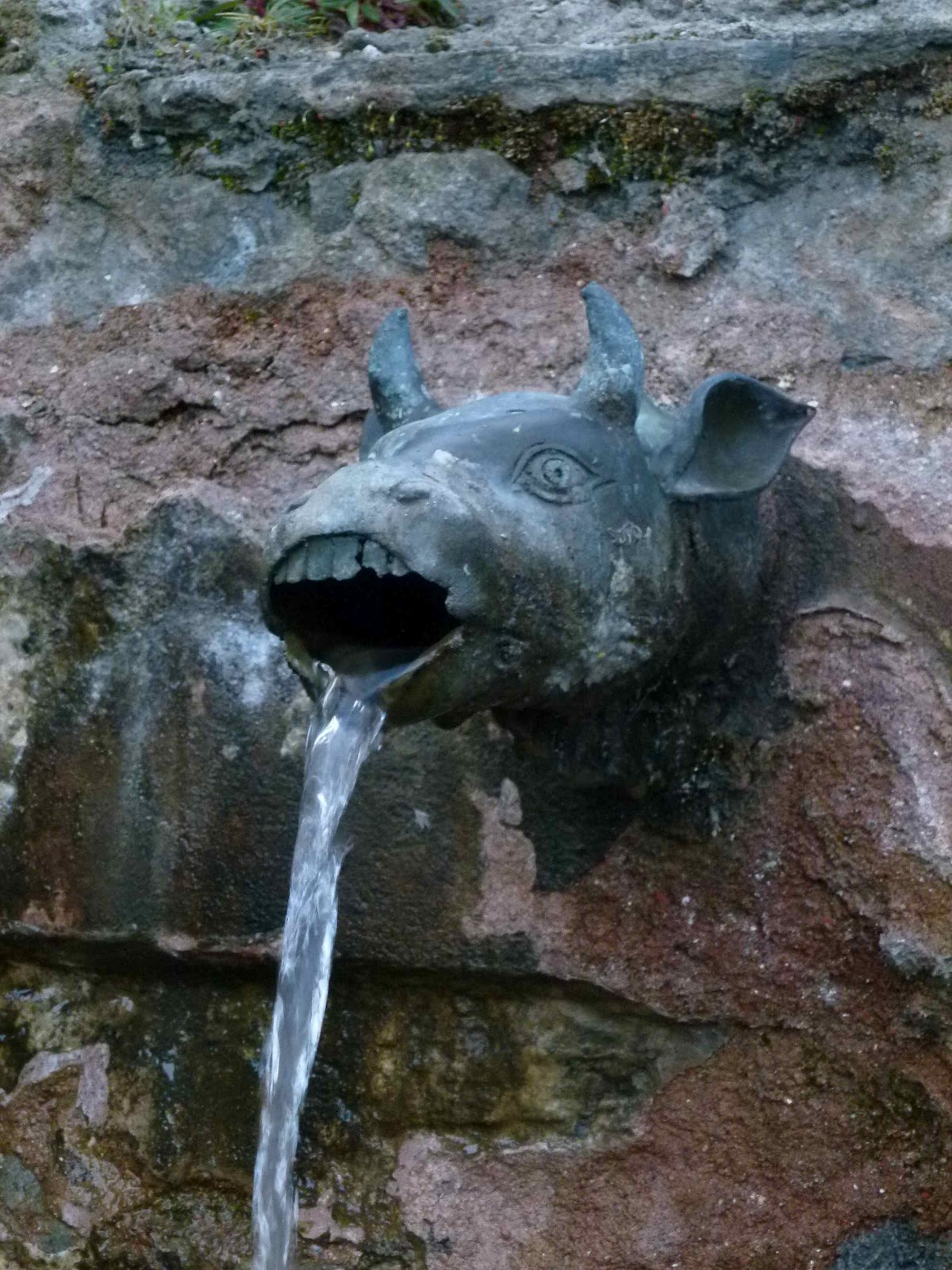
visited the main Hindu temple, a small pagoda structure dedicated to Vishnu,
Brahma and another of the Hindu pantheon of gods. Behind it, three walls with
cow head fountains showered water into a channel through which pilgrims purify
themselves.
 |
| Muktinath |
Further
up the hill, a small gompa dedicated to Guru Rinpoche had been demolished to
make way for a new one, and from here we gained fine views west to Tukuche
emerging in the early morning sun. More cloud today, and this was to build up
further during our temple visit. From here we visited another small gompa, this
one occupied by chanting nuns led by a male abbott. The central figure was a
Green Tara. This is a very special gompa as there is a natural gas vent here
and this is allowed to burn continuously, one of the reasons this location is
regarded as a sacred site. The nuns were chanting special mantras ahead of
tonight's full moon and the Saga Dawa festival in two days time.
We
finished our visit in the Samba Gompa, the entrance way featuring some fine
carved woodwork, and inside the central feature was a Medicine Buddha.
Returning
to the town for breakfast, we passed many saddhus, Hindu holy men, working
their way up to the temples.
 |
| Muktinath |
 |
| Heading for Jomsom... |
After
breakfast we made a quick descent through the villages below Muktinath, taking
a contouring path to bypass Kagbeni and take us straight down to Jomsom at
2750m, a drop of about 1000m.
It's
when we reached the Kali Gandhaki that we hit the wind. Since we had started
walking we had noticed the clouds building to the south and west of us. In the
valley bottom the wind intensified to the highest level we'd experienced yet,
gusting to around 40-50mph and throwing grit into our faces and exposed arms.
Ouch.
 |
| The trail from Muktinath to Jomsom...before the wind started to blast us! |
Anyway,
heads down, grin and bear it, true grit (excuse the pun!) and after four and a
quarter hours we reached Jomsom.
Seventeen
days on trek, a marvellous experience, made all the better for the effort we
had to put in and the new experiences for us all.
So,
guess, what? Yep, a beer sits next to the iPad, and we have a night in Jomsom
to get clean and prepare for an interesting flight down to Pokhara tomorrow!
As
it turned out, the weather changed significantly after our arrival. It actually
rained on and off all afternoon, clearing the air nicely. As the clouds started
to lift late afternoon, fresh snow was evident on all the surrounding mountains
down to about 4000m...so we had got down just in time. Lucky lads!
 |
| Windblown and sand blasted, Colin, Richard and John pitch up in Jomsom again! |
 |
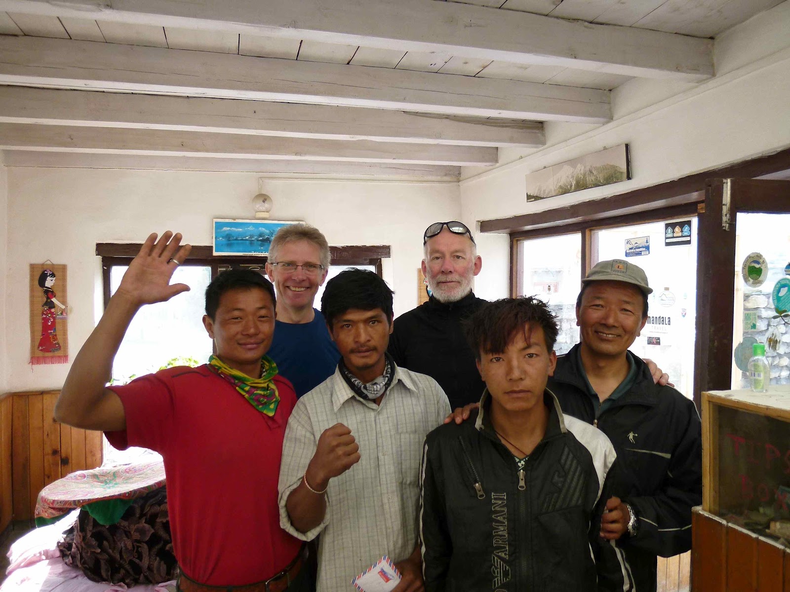
| Saying thanks to our trekking crew |
Monday
4 June
A
chill out day after we arrived safely from Jomsom.
One
of the alarming things about Jomsom is the wreckage of an aircraft on the same
route that remains above the town in
full view of the airport itself. The plane had crashed in bad weather 3-4 weeks
earlier with the loss of fifteen lives, including some tourists.
Anyway,
our flight was uneventful and with great views as we overflew much of the early
part of our trek up from Naya Pul almost three weeks ago.
 |
| Off to Pokhara...for beer and ice cream! |
Pokhara
is much hotter than up in the mountain valleys and the humidity built up during
the day, necessitating several ice cream and beer stops. It eventfully
thundered and rained in the late afternoon, clearing the air nicely, and we
enjoyed pleasant views across the Phewa Lake from our strategically positioned
bar stools.
We
stayed at the Mount Kailash Resort in the touristy Lake View area of Pokhara.
Quiet rooms and friendly, efficient staff.
A
massage, a Chinese meal for dinner nearby and early to bed.
Tuesday
5 June
A
lazy start, a good breakfast and a smooth transit through Pokhara airport for
our 0920 flight on Buddha Air to Kathmandu.
A
day of rest, some book shopping in Pilgrims Bookstore in Thamel, and dinner at
the Thai restaurant Yin Yang.
JOMSOM TRAIL & MUSTANG -
Summary
This
has been a truly 'Trans-Himalayan' experience. Trekking from the sub-tropical
climes above Pokhara, wending our way up to Poon Hill and the fine views of the
Annapurna and Dhaulagiri ranges, before entering the 'land that time forgot',
the brutal but wondrous landscapes of Upper Mustang.
We
didn't have enough time to do the full Annapurna Circuit, but the Jomsom Trail
was full of interest and acclimatised us well. In May/June it's hot, but the
trail generally clear of other trekkers, a real bonus on an otherwise popular
trekking route.
But
it was Upper Mustang, the ancient kingdom of Lo, that proved to be the star of
the show. Trekking here is not for the faint-hearted. It's windy, dusty, and
there are some long, isolated days of relentless ascents and descents across
the high altitude desert landscapes. But there are big rewards.
Empty
trails.
Some
of the most fantastic rock scenery you'll see anywhere in the world.
And
glimpses of medieval life up towards the Tibetan border. Indeed, the Dalai Lama
has said that Mustang 'is more Tibetan than Tibet'. And it is.
Tibetan
Buddhism survives here in an authentic, unfettered way. Cave monasteries,
gompas being lovingly restored, chortens and mani walls in profusion.
Absolutely wonderful. Just don't forget your face scarf!


10 comments:
Hi Colin,
my compliments for the beautiful photos and the trip comments too.
I have a question, being interested in going to Mustang soon. What about the carriageway from Jomsom to Lo ? How much of the trek is along it ? Is there relevant jeep/car traffic ? How much of the trail is on "pedestrian only" tracks ?
Many thanks in advance,
Enrico (Milan, Italy)
Hi Enrico
There is a rough gravel track, quite well graded, from Jomsom and onwards to Kagbeni. Some sections of the road drop into the gravel bottom of the Kali Gandaki Nadi, and will vary according to the flow patterns of the river. When we were there, there was a fair bit of traffic as far as Kagbeni, locals on motorbikes, many jeeps carrying Hindu pilgrims towards Muktinath, and lorries with supplies for communities up river.
Beyond Kagbeni, there is a gravel road, sometimes shared by the footpath, but often the path rises high above the valley and traffic uses a lower track and the valley bottom. Traffic flow beyond Kagbeni dropped off a lot. Vehicles can reach Chele, but have to stick to the river bed.
Currently from Chele to Samar there is no road, but they are building one which seems to go off in a different direction.
From Samar we took a high path to reach the Ranchung Gompa, so no raods here! But, the main path, I believe, joins a gravel road that has been built to cross the Yamda La and Syangboche La en route to Geling. Most tourist groups seem to go this way, but I wholeheartedly recommend visiting the cave gompa, but it makes for a very strenuous day.
From Geling, you will eventually reach a gravel road which, from the map, seems to go all the way to Lo Manthang, via Ghami and Tsarang. Our route used part of this road as far as Ghami (there was little or no traffic on this section), but there were no roads on the route north via Dhakmar and Ghar Gompa and onwards to Lo Manthang.
Our southerly return route followed the gravel road from Lo Manthang to Tsarang. Some jeep and motorbike traffic and a couple of trucks, presumably carrying Chinese goods into Nepal, but traffic was light. Beyond Tsarang, the road (mentioned above) goes southwest to Tamagaon and over the Yamda La, but I think it's still being built beyond that point.
However, from Tsarang, we were away from roads completely until we re-entered the Kali Gandaki valley from Muktinath.
Hope this helps! Go soon, the road-building will, I'm sure, link the Tibetan border north of Lo Manthang with Kagbani/Jomsom in the next couple of years, and the floodgates of tourists and goods will change this region forever.
Best wishes
Colin
Best map is the Himalayan Map House NP108 Mustang, 1:100,000
Hi Colin,
many thanks for your detailed reply. It is very useful to have comments from experienced people.
Yes it is my feeling too that it is worth to go soon to some places where roads are being build.
I have concern for Naar-Phu too, considering the road that is going up from Besisahar to Manang. Since a long time Annapurna Circuit is no more wild, but all the region will dramatically change in a short time I think.
Anyway, on the Alps we have a lot of roads and that helped our people a lot.
It is difficult to manage economic development, environment protection, people wellness ... but it's just a trivial comment, of course.
Thanks-you very much again
Enrico
No problem Enrico.
Yes, it's very easy for westerners like ourselves to be disparaging about road building, but the positive impact in enabling easier access to education, medical care and improved economic conditions cannot be denied. There is no 'right answer' but with support from the west, let's hope that the traditions can be maintained as well. The American Himalayan Foundation is doing great work on monastery restoration in Lo Manthang, for example.
Safe journeys
Hello Colin,
I still take advantage of your kindness through this blog, hoping not to be boring for other readers.
Do you have any hint to climb Thorung La from the Muktinath side ? My wife and I wish to cross it that way, descend to Manang and then go back to Jomoson through the Tilicho Lake region and the Mesokanto La. The problem I see is that Thorung La climbing could be too long on that side, for us and for the crew too, if departure is Muktinath. Not clear if there is a camp half way.
I know the trip is ambitious, but my wife and I are experienced and trained.
Thanks,
Enrico
Hi Enrico
I am not really qualified to comment as I haven't done this section of the Annapurna Himal.
The Lonely Planet Guide to Trekking in the Nepal Himalaya says it's a 1620m ascent (followed by a 1040m descent), a big day by anyone's standards and the pass could be blocked by snow when you get there.
According to my copy of the guide, an old edition, there's a lodge at Chabarbu 4290m (1.5 hours out of Muktinath), although it's uncertain whether accommodation is available here.
Apparently, the start of the ascent from Muktinath is fairly easy valley climbing (the path looked good from Muktinath), eventually reaching steeper switchbacks through moraine (possibly indistinct), with the potential for snow from there on at any time of the year. There is a small stone hut at the top of the pass.
The route down from the pass is also steep down through moraine, but well defined.This section takes 4-6 hours to CLIMB from Thorung Phedi, so you'll need to allow, say, another 3 hours to descend from the pass?
i'm unable to help with the Manang to Jomsom route, sorry.
Sounds like a great trip. Do make sure you're using good local guides: the guides at Dharma Adventures in Kathmandu (info@dharma.com.np) know the region well, and I've worked with the excellent Exodus Trekking company in Kathmandu over the years who will be happy to help: etrks@mos.com.np
Good luck!
Colin
Thank-you very much. I hoped in your direct knowledge. Much of the books and of information available on the Web deals with the counter-clockwise Annapurna Circuit and do not foreseen a camp descending from the pass to Muktinath. I'll let you know whether we'll complete this program or not.
Best wishes,
Enrico
It’s wonderful to read your account hours before I leave for jomsom. It’s one of the best blogs I have read on the region!
Wonderful
Post a Comment