Within a hour or two, we started a steady climb up the Teesta River gorge, a busy road with a few hair-raising overtaking moves by everybody as they attempted to make progress, albeit with much honking of horns but no hassle, up this winding spectacular road. Passing groups of nonchalant monkeys, surveying us quizzically as the human race frenetically passed them by, the views became increasingly spectacular, with views down to the glacial river flows far below, a number of hydro-electric developments and industrious little hill villages, with many of the properties perched precariously on stilted foundations on the steep valley sides.
Just before dark, the first signs of a more devout local Buddhist culture started to appear with prayer flags appearing before we crossed the bridge at the border of West Bengal and Sikkim. We stopped here, in the town of Rangpo, for a short break and enjoyed one of the local brews, Dansberg Lager, the creation of a local Bollywood star and entrepreneur.
 |
| Gangtok |
Another couple of hours, driving in the dark on increasingly steep roads, brought us to our destination, the town of Gangtok, and our hotel Netuk House, a charming family run hotel situated high above the town. The sky had become increasingly ominous during the afternoon, and, almost to trumpet our arrival, the heavens opened as we enjoyed our welcome nip of cherry brandy and very pleasant evening meal shortly after.
Turning in for the night, distant thunder and rain hammering on the metal roof of my room didn’t quite serenade me to sleep, but, hey, I’m in the mountains again, so what should I expect?!
Footnote: we were to learn later in the trip that two hours after our landing in Guwahati, a bomb had exploded in the nearby city centre, killing eight and injuring 150 people, an attack by Assam separatists a day ahead of the planned visit of the Indian Prime Minister. Our guide was quite open…’Assam is not a safe place’.
Day 3
A little on Sikkim before I describe the day’s explorations from Gangtok. Originally populated with the peoples of Assam, Burma, and Tibetans fleeing religious strife, the kingdom of Sikkim came into being when three refugee lamas from Tibet crowned Phuntsog Namgyal as the first chogyal (king) in 1641. Gangtok eventually became the capital, and the kingdom came to embrace eastern Nepal, upper Bengal and Darjeeling. The population swelled with large numbers of Hindu Nepalis in the 19th century, and eventually the British managed to cede Darjeeling to the East India Company, causing ongoing problems with Tibet.
Finally, in 1975, Sikkim lost its independence and became part of India, but China has only recently recognised India’s claim, and Delhi has kept inward investment into the state high in order to bolster sentiments towards Indian rule. India still retains a strong military presence in the area, and you require a special permit to travel in Sikkim, with additional special permits to undertake high altitude treks like the one we are about to embark on…more stamps for an already busy passport!

The ecology around Gangtok (our hotel being at 1780m) is essentially sub-tropical, with banana trees, palms, terraced rice fields, orchids and a panoply of ferns and brightly coloured butterflies. So, on to the day. An early breakfast, and a visit to the nearby Enchey Gompa for our first taste of Tibetan Buddhism. Dating from 1909, it is a small monastery, and the main hall was being restored during our visit. Set in attractive gardens amidst conifers, it did produce the usual sense of calm that is so common when you visit these revered places. Then a quick visit to an orchid show. That lasted ten minutes.
 |
| Rumtek Monastery |
Our next port of call was the more significant Rumtek monastery, just 26km away but involving an ascent and descent on to a neighbouring ridge of some 650m and, on the way there, a journey time of one hour 40 minutes due to urgent road repairs being affected just short of Rumtek. This is the most important monastery in Sikkim, the home of the Kagyu (Black Hat) Buddhist sect, and was mercifully free of visitors on our arrival. The main hall was truly impressive, with a giant throne within which awaits the inauguration of the sect’s spiritual leader, the 17th Karmapa, a young man who fled Tibet in 2000 but is currently confined to Dharamsala by the Indian government so as not to cause affront to their Chinese neighbours. I won’t say on this page what I think about that.
The gompa is part of a big teaching complex and above the main hall there is an attractive Golden Stupa which holds the ashes of the 16th Karmapa. A well maintained gompa, well worth the visit. Go early!
A quick cup of chai and some vegetable momos and then one hour back to Gangtok to visit the equally impressive Namgyal Institute of Tibetology, with some awesome Buddhist relics, thangkas, ancient books and manuscripts. On the top floor was an interesting photographic display chronicling the parallel dynasties in Sikkim and nearby Bhutan.
A good lunch and then back to the hotel in torrential rain for tea. Some of the group then set off to do some shopping in the local markets – not yours truly – but not before being treated to a glimpse of the snow capped Kanchenchunga range, emerging temptingly from behind banks of storm clouds. Praying for clear weather in the days ahead!
A stunning sunset closed off the day nicely.
Day 4
Up early and awarded with a distant view of our objective, the Kanchenchunga range. Although a long way off the fine pyramidal peak of Koktang, and adjoining Ratong and Kabru were clearly visible, and to the right could be seen the lofty mass of Kanchenchunga itself, the jet stream at the summit creating a trail of cloud in its wake.
We had a long day in the jeeps to reach Yoksum, a village at about 1780m and the start point of our trek.
Dropping down from Gangtok, we turned westwards in Singtan, before slowly working our way around the many valleys leading us to a lunch spot in Rabang at about 2200m, with other stops at a suspension bridge and a fine waterfall. The roads were challenging for our drivers, with numerous rough patches and the occasional diversion due to landslides (and a large snake crossing the road ahead of us), a common feature of life in this part of the world. Needless to say, the views all day were superb, with terraced slopes, huge stands of bamboo and other sub tropical vegetation, although after six to seven hours of driving we were all desperate for some exercise at the end of our journey.
Yoksum is a very small settlement, festooned in Buddhist prayer flags at an altitude of 1780m and we quickly got ourselves settled in the tents before an hour’s walk to the Dupdi Monastery, the oldest in Sikkim. As we reached the monastery, about 300m above the village, the clouds darkened considerably and a thunderstorm started in earnest, drenching us on our slippery return. Our descent was enlivened by a group of very cheery monks singing themselves all the way to the top.
A rest, dinner and early to bed. The trek routine starts here!
Day 5
Not a bad night’s sleep although the expected barking dogs disturbed it somewhat. Reaching for a stuff sac first thing I happened upon a leech…horrible things…a feature of wet weather conditions at this altitude. Yuk.
Breakfast and off by 0745 for an easy walk out of the village before gently ascending into the forest, trees festooned with moss and creepers, with unusual birdsong to accompany us on our way. It was a well maintained path, and relatively busy with trekkers and one large Indian school group, but there were many moments of splendid isolation. The path contoured a series of heavily wooded interlocking spurs, with views to the cascades of a glacial river far below us.
Crossing a number of suspension bridges and staying well ahead of our cook crew, we had a tea stop in the tiny hamlet of Bakkhim, before the final pull up to Dsoka (Tshoka), a village mainly inhabited by Tibetans who spend the warmer months here.

There is a fine little monastery just above the village and some breathtaking views back down into the valley. We are now at an altitude of 3050m, so we’ve worked hard today! At this level we saw more bird life, some long tailed magpies and a bright blue sparrow, who flit among the red rhododendron trees and stands of white magnolia. Dsoka is a very atmospheric spot, made more so by giant cumulonimbus building to herald another thunderstorm ahead.
Our night was to be spent in a simple lodge, four of us men in a single storey bunk room. A good dinner, then early to bed. Surprisingly, it was a to be a fitful night but the rain had stopped by 1000 and a pee visit was rewarded by the sight of the high mountains around us lit by a full moon.
Day 6
As I write this diary today, I’m sitting in a tent, in a five season sleeping bag at just under 4000m. It’s mid afternoon, and it’s been a big day of ascent, starting at 3050m and finishing at 3950m above the camp and huts at Dzongri. The route started in Dsoka, where a bright blue sky greeted us and we had our first real view of the higher mountains, freshly festooned with new snow from last night’s storm.
There is a small monastery at Dsoka, in the most idyllic of locations, and was particularly photogenic in the early morning light. The path climbed very steeply out of the village and was made easier by the sterling work of the Sikkim people who have laid literally thousands of logs to enable trekking parties to avoid the glutinous mud on the path.
 |
| Monastery at Dsoka |
Up and up, then a plateau vegetated by high rhododendron trees, then a further climb up a similarly steep and increasingly snow covered path, eventually topping out at about 4000m and great views to the high mountains all around us, with deep valleys acting like cauldrons for huge banks of cloud.
We are now at the tree line and the vegetation is now mainly lower rhododendron bushes and boggier ground generally.
Our campsite is a grassy plateau, exposed to the elements, and the snow started to fall in earnest as the crew pitched camp. Into warmer clothing, then into the tea tent to enjoy refreshments and freshly cooked pokhoras…delicious!
It’s cold and windy here, probably an indicator of what to expect over the next five days, but that’s the sacrifice you have to make to see such remote and majestic mountains at close quarters.
As the afternoon wore on, the clouds cleared, and a short walk to a nearby chorten afforded great 360 degree views, east to Pandim 6691m and Jopuno 5936m, and west to Panding 5172m. Immediately to our north was 4810m Kabur, a small peak of the same height as Mont Blanc and within touching distance of our camp site.
Dinner, early to bed…a 0400 start beckons tomorrow.
Day 7
A cold night and broken sleep throughout with the expectation of an early wake up call. Woken at 0400 and on the hill for 0430, our objective a small top, christened somewhat ambitiously as Dzongri Peak, from which we would get our first proper view of Kanchenchunga. With a waning moon to help us see the way up, we were on the top just after 0500, and in a clear dawn, experienced the stunning vista of the Singalila Range to our north, the most pronounced peak being Kabru, standing at over 7300m, with Kanchenchunga appearing lower due to the fact that it was further away. Magnificent.
To our right stood Pandim, and a ridge running south with numerous 5000m+ tops, one recently renamed after Tenzing Norgay, Sir Edmund Hillary’s partner on the first ascent of Everest. Superb mountains with ice flutings and hanging glaciers, albeit much shrunken from past levels due to climate change.
A quick descent and back in the camp for 0600 and the usual pack/breakfast routine. It is to be a short day today, with only four hours walking, with an easy start westwards to a saddle which gave clearer views on Kanchenchunga and Pandim, before a steep descent to the valley of the Prek Chu.
With some snow underfoot, some sections were a little tricky, but the steep final section of some 200m brought us swiftly to an attractive river valley, carving its way through masses of rhododendron trees, unfortunately yet to flower.
Turning north, we followed the river upstream, crossing numerous small bridges, before a final pull up through the forest to the large camp site at Tangshing, altitude around 3875m.
This turned out to be a populous site, with a few groups of trekkers converging to attempt the Goecha La, our trip objective in a few days time after some more acclimatisation. Ponies, dzo (a mountain pack animal, similar to the yak, but with shorter hair), the occasional wild yak (firmly repelled by the dzo boys) and myriad nationalities of trekker. We’re now virtually under Pandim, with its impressive summit ice cornices.
Slightly warmer than the previous night, the afternoon turned increasingly cloudy and it was difficult to resist a much needed afternoon nap. Thereafter, the usual afternoon tea/dinner/early night routine.
Day 8
Before I cover today’s adventures, having spent nine hours in a tent, situated in a broad river valley at about 3900m, I thought I would spend a few moments explaining what trekking really means. Quite simply, you walk for hours, enjoy fine views and company, then spend the rest of the day fantasising about all the food treats and favourite beers you’d kill for, trying to get clean, forcing down food you don’t really want because of the effect of altitude, then trying to sleep with pony men playing cards late into the evening, ponies and dzo wandering outside trying to eat your tent (OK, that bit’s an exaggeration). Oh, and then there’s the sleeping bit…freezing cold damp air in the tent so you bury your head into your down bag, overheat, get your head out to cool down, then decide you need a pee, which then involves getting out of your sleeping bag, then going through the whole cycle again…all night. I really love trekking.
So, what did we get up to today? It was a beautifully clear start to the day, with frost on the ground and magnificent views of Pandim, with its ice-encrusted summit, towering above us.
 |
| Pandim 6691m |
Today, Easter Sunday, is carded for an acclimatisation walk. A ‘short walk’ is how our guide Dillip explained it. We set off in fine hot weather and ascended a spur overlooking the camp site before encountering the first of several icy sections which made for very tricky walking.
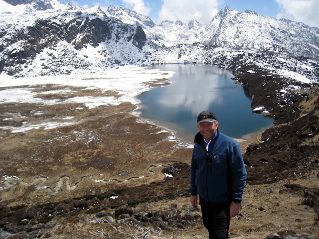
But we soon got past these and joined a fine contouring path, which stretched for about 7km to a corrie lake known as Lam Pokri.
We had great close up views of Pandim, Jopuno (newly renamed Tenzing Kang) and Narsing rising high above our path, with their forbidding ice walls and rock buttresses. And, splendid views north to Ratong, the mighty Kabru (a fine looking peak) and Kanchenchunga in the middle distance. The final 200m up to the lake was a struggle for most of us in the group, the altitude still taking its toll, but it was worth the effort with fine views down to the lake and far beyond. On this section we disturbed a few pheasant, who obviously nest in the myriad low rhododendron bushes. We reached an altitude of about 4200m.
 |
| Lam Pokri |
Returning the same way, with clouds billowing up below us, we continued to enjoy fine weather and, thankfully, the daytime temperatures had melted the ice on the lower rocky sections. Relief!
Back in camp 7 hours after we set off, the walk will not have set any records, but will have done a lot of good in preparing us for the rigours of the trek ahead.
The afternoon continued clearer than previous afternoons with high clouds on Pandim creating a ghostly spectacle.
 |
| Camp under Pandim |
Day 9
The day dawned with some more cloud than previous mornings and we were soon on our way for a short day walk to our next camp (the ‘base camp’ for our high point the following day). Walking up the broad upper section of the Prek Chu valley, we gained height easily, and went on past our camp site for the night to climb up to Lake Samiti (Sungmoteng on the Swiss map of the area, after the Tibetan version) at 4200m. The view from this lonely lake, set amongst the moraines bounding the Onlaktang Glacier, was obscured by building clouds, although we were entertained by a couple of wild yaks grazing the lake shore. We were able to see our route for the next day, which would be done in the dark in our attempt to reach the Goecha La for its famous views of the impenetrable S.E. Face of Kanchenchunga.
We returned the same way, in increasing winds, to the camp site at Lambi (Onlaktang on the map), a windy spot at the head of the valley.
The weather then deteriorated, with frozen rain, snow, rain and increasing wind strength into the afternoon. Oh well, we’re in the mountains…what else should we expect?
Very early to bed tonight, ready for an 0215 wake up call to get us on the hill in time for sunrise on the big wall of high mountains now only a few km away from us now.
Day 10
The night did not bode well for our attempt on the Goecha La, with a strengthening wind during the night and some snowfall. Dillip abandoned our very early start but made a call that the weather would improve and had us up at 0315. Time for a quick breakfast and we were all off on the trail by 0410, with head-torches helping us carefully pick our way up into the moraine of the nearby Onloktang Glacier. Fairly easy going, and we passed around the lake visited the previous day, before picking our way up a steepening valley towards our objective. Here the rocks became increasingly icy so care was required, but after 30-40 minutes of this we were rewarded with the intense light of the early morning sun breaking on the wall of brilliant white mountains towering above us.
Encouraged by this sight we moved quickly up some deeper snow slopes, took a batch of pictures before traversing a tricky little snow covered path which led us to a fine viewpoint, festooned with prayer flags, and views to the mighty Kanchenchunga, the world’s third highest mountain at 8585m directly ahead.
 |
| Kanchenchunga |
Below us to our left were two large glaciers, flanked across the whole skyline by the fabulous peaks of Kangla Kang, Koktang 6147m, Ratong 6679m, Kabru South and North Peak (7317 and 7388m respectively), Talung 7349m and Kanchenchunga itself. Immediately behind us towered the North West Face of Pandim. A great spot, and probably one of the best mountain vistas in the world.
 |
| Viewpoint below the Goecha La |
Goecha La, a high pass at 4900m, and a closer viewpoint for the massive South East Face of Kanchenchunga, looked tantalisingly close but was actually at least 2.5 hours away, across boulder fields, now covered in fresh snow and ice.
Accordingly, the group took the (very sensible) decision to savour this view then reverse back to camp. It would have been arduous and risky walking, with the probability that the clouds would have built up during the walk and subsequently obscuring the very view you had worked for.
Our decision was vindicated when the clouds started to build up during our descent and ultimately obliterated the high mountains completely (meeting another group on the trail the following day, two of their number had attempted to get to the pass but had retreated after reaching thigh deep snow with no visibility).
Returning to camp, taking care on the icy track, we reached the Lake Samiti once again, perfectly still and with great reflections of the surrounding slopes. We also had a chance sighting of the elusive blue sheep, similar to those seen in Ladakh last year.
 |
| Lake Samiti |
A stop for a rest and second breakfast of the day, and we were on our way again back down to Tangshing for another night’s camping before the long descent back to Dsoka, where tomorrow we hope to rest again at it’s simple lodge.
Tangshing turned out to be a cold and windy stop, with rain confining us to our tents for most of the afternoon, but giving us good time to catch some much needed sleep. Just before dark we did, however, find some amusement with a crude game of skittles on the camp field…simple pleasures! A foggy, cold night.
Day 11
The day dawned bright with fine views back up the valley to Kanchenchunga and Pandim to our right. We set of back down the Prek Chu valley, and then continued along a contouring path that wended its way through the forested slopes of the many interlocking spurs.
Rhododendron trees and sweet smelling pine trees dominated the slopes although late snows this year had killed many buds so flowers were few and far between.
The path was narrow in places, with some steep drops and some slippery patches due to either ice or mud, but it somehow maintained an average height of 3600m for about 3.5 hours. We eventually reached the high meadow at Phedang for a quick lunch.
Descent then started in earnest with over 500m lost as we repeated the first part of our climb on Day 5, initially steep and rocky then reaching the wooden logs which the local people have laid across the path to prevent erosion. A few more flowers seen at this level, but they’ll probably flower in earnest when we leave the area! The quality of paths in this region are worthy of mention. Twice a year, local people are funded by the Sikkim Tourist organisation to maintain the paths. Many are destroyed by landslides during the monsoon, trees collapse over the path and other sections turn into quagmires. The work they do is impressive and makes trekking much more palatable than it would be otherwise.
We reached Dsoka mid afternoon and enjoyed some refreshments in the little Tibetan store above our lodge for the night. Fine weather all day! A mixed night as I was sleeping on the floor of the lodge, but as there was heavy rain in the middle of the night, I’m not going to complain too much!
Day 12
Our final day on trek and it dawned with relatively clear skies. It’s amazing how much height we’d climbed on our first day and you only really get to see the shear amount of work you’d done when you have to reverse it! Today’s descent was almost 1200m, so sore knees were the order of the day. The first section was a pleasant series of zigzags in cool sunny weather, taking us down to the smallholdings of Bakkhim through forest with red and purple rhododendron and white magnolia in greater quantities we had seen at higher elevations.
The path progressively steepened, and the air became much more humid as we reached the first major suspension bridge at about 2250m. Anybody nipping into the bushes for a quick natural break ran the gauntlet of leeches at this elevation, as one of our number reappeared with six of the little blighters attached to his boots.
Ghastly creatures… and we were to see many more attached to small plants adjacent to our pathway as we descended further.
The forest eventually becomes semi-tropical around the 2000m level, with jungle-like creepers, moss covered trees and more vocal birdsong and cicadas to accompany you downwards.
It was a busy day on the trail, with frequent stops as groups of dzo or ponies attempted to get past each other on an increasingly rocky trail. One of the issues in Sikkim is alcoholism and we were unfortunate enough to see one porter, completely incapacitated on the local hooch, rakshi, fall off the trail and narrowly avoid plummeting to his death hundreds of metres in the precipitous forests below the trail. He was carrying the ‘kitchen’ for a group ascending the trail, so I don’t expect that group to have dined well that night!
As we descended further, much of which was on an undulating and increasingly slippery path, the humidity increased, although we were rewarded with the sound of our first cuckoo of the season.


A long descent, with lots of ups and downs, so we were all relieved to finally reach Yoksum once again. We checked into the Hotel Pemathang and were soon ensconced in a local café cum bar for an extended sampling session of two locally brewed beers, the inoffensive Dansberg and the more potent ‘Hit’ (the label says that the strength is ‘not less than 8%’!), so the beer drinkers quickly lapsed into talking gibberish! Two of us were even sufficiently fortified to brave a local barber shop for a hair and beard trim (yes, by now, I was sporting 12 days growth!), with a rather scruffy barber with cut throat razor who also did a little chiropractice at the end of the session. The alcohol helped! Whilst we sat under an awning outside the café we were to witness an almost monsoon like downpour… the locals have much to endure here.
Back to the hotel to bid farewell to our pony men, mountain guide Pamtuk, and the cook team, who, incidentally, prepared their final meal for us in the hotel kitchens (still cooking on the floor as they did throughout the trek). Tips were presented and national songs exchanged. A fun evening, although as usual the local dogs did their best to disrupt our night’s sleep.
Day 13
The day dawned relatively bright, and there were views back to the snow capped peaks from the bedroom window. It was a relatively comfortable night, although one couple had been disturbed by a large cockroach in the night.
An early start for a long drive south to Darjeeling, the famous hill town in W Bengal. Travelling by jeep again, we were reminded of just how high the start of our trek at Yoksum was, as we spent hours descending on very windy and often rough roads through magnificent scenery…deep valleys, terraced slopes, stands of bamboo, cardamom bushes and all manner of village life. This is great country, with fascinating villages perched atop narrow ridges.
We eventually reached the Rangit river valley beyond Lepship and had a tea stop in the town of Naya Bazar, just before crossing the border into West Bengal, this necessitating another passport stamp. At this point we had descended over 1200m from Yoksum, but over the next two hours we were to regain this, and more, to reach our destination of Darjeeling at over 2100m. Crossing the border into West Bengal (or Gorkhaland as many prefer to call it due to the majority of the people here being Gurkha settlers from Nepal), the scenery changes almost immediately. Rising steeply on narrow roads with many hairpin bends and precipitous drops in all directions, you quickly reach the famous tea plantations of the Darjeeling area, with brightly clothed women plucking tea leaves amongst swathes of tea bushes reaching as far as the eye can see.


